 Log In
 Register Now!
 Help
Help

Amazing Work Paul. http://www.elvastower.com/forums/public/style_emoticons/default/clapping.gif The effort in itself can't be overly applauded but along with that one must recognize the artistic talent being displayed. You are indeed displaying a tremendous amount of that. You are a true inspiration.
Paul http://www.elvastower.com/forums/public/style_emoticons/default/biggrin.gif
Surfliner 2 Retexturing
Giving a favorite route a new look
Rate Topic:

#201

- Foreman Of Engines
-

- Group: Status: First Class
- Posts: 934
- Joined: 18-June 11
- Gender:Male
-
Country:

Posted 04 February 2017 - 05:35 AM
#202
- Executive Vice President
-
- Group: Status: First Class
- Posts: 4,655
- Joined: 25-February 05
- Gender:Male
- Location:San Diego
- Simulator:ORTS
-
Country:
Posted 04 February 2017 - 01:27 PM
Paul, on that climb up Miramar grade, MasterChief installed some pretty serious bridges but they don't actually exist. Wherever he has bridges there are culvert pipes only. Just an FYI.
#203
- Open Rails Developer
-

- Group: Status: Elite Member
- Posts: 3,733
- Joined: 15-January 04
- Gender:Male
- Location:Eastern Oklahoma
-
Country:
Posted 04 February 2017 - 04:20 PM
paulytechnic, on 03 February 2017 - 09:08 PM, said:
They're 512. I briefly considered 1024, but soon realized the much larger file size across a few thousand terrtex files would really add-up fast.
Thanks for the reply! That you're getting such good results using only 512's is very encouraging in view of some of the projects I have on my hard drive.
#204
- Conductor
-

- Group: Status: Active Member
- Posts: 393
- Joined: 26-January 11
- Gender:Male
- Location:Tampa, FL
- Simulator:Open Rails
-
Country:
Posted 04 February 2017 - 06:19 PM
atsf37l, on 04 February 2017 - 01:27 PM, said:
Paul, on that climb up Miramar grade, MasterChief installed some pretty serious bridges but they don't actually exist. Wherever he has bridges there are culvert pipes only. Just an FYI.
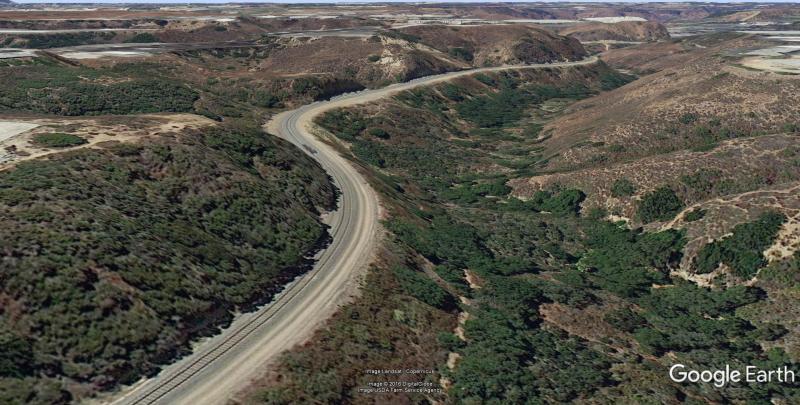
Well, whadda ya know 'bout that! http://www.elvastower.com/forums/public/style_emoticons/default/shock6.png A quick view in Google Earth, taken from the same angle as my MSTS shot on the last page, confirms the lack of bridges (although I didn't doubt you, Herb! http://www.elvastower.com/forums/public/style_emoticons/default/wink.gif)
To be honest, I always kind of liked the look of those bridges along there, but now that I know they're not prototypical ("gasp!"), it'll probably eat away at me until I do take them out. The good news is that it's probably a fairly easy fix; a few strategic presses of the 'Y' key in Route Editor should fill the embankment fairly quickly (hopefully).
My question is now, would anyone happen to know what sort of culverts happen to be there, such as a basic round pipe, or the box type (I know Jeff already used some of the box ones elsewhere in the route)? There's always artistic license if all else fails.
#205
- Fireman
-

- Group: Status: Contributing Member
- Posts: 123
- Joined: 01-September 08
- Gender:Male
- Location:Ridge, Dorset, UK
- Simulator:MSTS & OR
-
Country:

Posted 05 February 2017 - 12:42 AM
paulytechnic, on 04 February 2017 - 06:19 PM, said:
Well, whadda ya know 'bout that! http://www.elvastower.com/forums/public/style_emoticons/default/shock6.png A quick view in Google Earth, taken from the same angle as my MSTS shot on the last page, confirms the lack of bridges (although I didn't doubt you, Herb! http://www.elvastower.com/forums/public/style_emoticons/default/wink.gif)
GoogleEarth_MiramarGrade.jpg
To be honest, I always kind of liked the look of those bridges along there, but now that I know they're not prototypical ("gasp!"), it'll probably eat away at me until I do take them out. The good news is that it's probably a fairly easy fix; a few strategic presses of the 'Y' key in Route Editor should fill the embankment fairly quickly (hopefully).
My question is now, would anyone happen to know what sort of culverts happen to be there, such as a basic round pipe, or the box type (I know Jeff already used some of the box ones elsewhere in the route)? There's always artistic license if all else fails.
Well as someone who likes driving a lot of the time "outside" (what nowadays we could call "drone cams"? 2&3) I'd have to say that even then it's the scenery and the train I'm looking at ....but the shape of a culvert? Well if you can't see it in Google Earth isn't worrying about it in MSTS just a distraction from the bigger picture? :pardon: Just my two penneth. Watching this with patient anticipation for a release. :sign_thanks:
#206
- Executive Vice President
-
- Group: Status: First Class
- Posts: 4,655
- Joined: 25-February 05
- Gender:Male
- Location:San Diego
- Simulator:ORTS
-
Country:
Posted 05 February 2017 - 01:47 AM
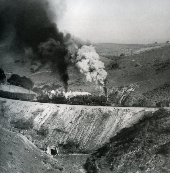
Well, as a matter of fact, I do. Now I can guarantee you that the old California Southern had a trestle at this point where the big fill is but it has been covered up with dirt! The culverts were substantial concrete affairs and are so far down that it is hard to see them in things like the Google view. Of course you also have to take into account that the Google view is of the new double track right of way that is being installed so the original culverts have probably been replaced as they would be too short to penetrate the wider fill. Photo taken by Phil Middlebrook, image from SFRH&MS/Stan Kistler collection, as published in John Signor's Los Angeles Division, P. 283.1947, upgrade at Soledad Canyon just a little bit east of today's 805 highway, if I'm not mistaken.
Here maybe?
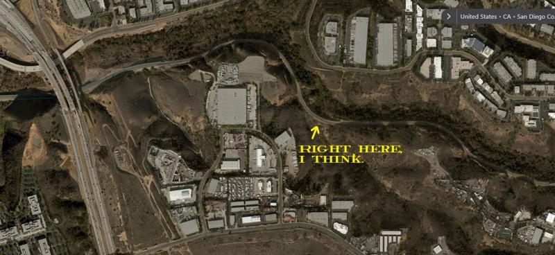
:bigboss:
Here maybe?
:bigboss:
#207
- Fireman
-
- Group: Status: Contributing Member
- Posts: 123
- Joined: 01-September 08
- Gender:Male
- Location:Ridge, Dorset, UK
- Simulator:MSTS & OR
-
Country:
Posted 05 February 2017 - 03:14 AM
atsf37l, on 05 February 2017 - 01:47 AM, said:
Don't get me wrong. IF it's an easy fix it's worth doing .....BUT your very picture raises the reality of MSTS route building? There is a limit to the number of objects that can be placed, in reality it would be almost impossible to custom build the correct major structures for all visible buildings? So in the scheme of things the shape of the culvert compared to how "convincing" major buildings and foliage looks is surely rather small fry? Face it those who drive from the cab are never going to see a culvert down there :unknw:
#208
- Conductor
-
- Group: Status: Active Member
- Posts: 393
- Joined: 26-January 11
- Gender:Male
- Location:Tampa, FL
- Simulator:Open Rails
-
Country:
Posted 05 February 2017 - 06:50 AM
Agreed...a culvert is by no means a major enough feature to warrant a custom model. Since models of multiple types are already available to use, it's just a matter of choosing one and dropping it in. (The one in Herb's photo almost looks like a shrunken-down tunnel portal.) In terms of MSTS limits, I'm not really worried about object count, since I'll be removing about 3 pieces per bridge (end piers and the span itself) and replacing with only 1 or 2 objects.
From exploring around in Google Earth, it's definitely apparent that most of the culverts are well buried beneath the foliage, so I'm thinking a good compromise would be to place the upper culvert, but not the lower (since it's fairly well hidden, and wouldn't be a distraction). Speaking of foliage, I'm now realizing that my terrtex in that area seems a bit too grassy, while in reality, that area has more heavy shrubs and trees. I'll need to update the terrtex around the removed bridges anyway, so I'll update more of the surrounding valley at the same time.
From exploring around in Google Earth, it's definitely apparent that most of the culverts are well buried beneath the foliage, so I'm thinking a good compromise would be to place the upper culvert, but not the lower (since it's fairly well hidden, and wouldn't be a distraction). Speaking of foliage, I'm now realizing that my terrtex in that area seems a bit too grassy, while in reality, that area has more heavy shrubs and trees. I'll need to update the terrtex around the removed bridges anyway, so I'll update more of the surrounding valley at the same time.
#209
- Executive Vice President
-
- Group: Status: First Class
- Posts: 4,655
- Joined: 25-February 05
- Gender:Male
- Location:San Diego
- Simulator:ORTS
-
Country:
Posted 05 February 2017 - 03:05 PM
Geoff, don't shoot the goram messenger. Paul asked if I had a picture and it was provided. :bigboss:
#210
- Fireman
-
- Group: Status: Contributing Member
- Posts: 123
- Joined: 01-September 08
- Gender:Male
- Location:Ridge, Dorset, UK
- Simulator:MSTS & OR
-
Country:
Posted 06 February 2017 - 12:02 AM
atsf37l, on 05 February 2017 - 03:05 PM, said:
Geoff, don't shoot the goram messenger. Paul asked if I had a picture and it was provided. :bigboss:
No intention of "shooting messengers" and the pictures are great. :wtf01: My point is the merely that the culverts themselves are not what the SIM user would see .....unless they were looking for them? Your aerial shot shows a massive diversity of buildings in that area and to even represent those convincingly is an art in itself?