 Log In
 Register Now!
 Help
Help

Appreciate your positive feedback everyone. Thanks!
Andre:
The link and pin era on the line was very interesting. It took a long time to construct the Mullan Tunnel. Good hard rock was experienced when they began portal-ling in from the east side of the divide, but as they bored further in the ground became steadily looser and unstable. As such, it was found necessary to put in an "overhead line" on top of the pass at a 4.4 percent grade. This would be the route that former President Ulysses S. Grant and the German ambassador would take over the Continental Divide to attend the last spike ceremony of the first transcontinental railroad in the Northwest.
Despite the eventual completion of the tunnel in Nov. 1883, the overhead line had to remain available as cave-ins continued rather frequently. After some time in 1887, the tracks on the overhead line were finally removed when confidence in the tunnel finally improved; however they had to be relaid again after another large collapse in 1888. On another occasion, the wood shoring in the tunnel caught fire and the overhead line was again put back in to service. On top of all that were the usual brake and coupler failures on the trains themselves that had to be contended with. Quick thinking and action of NP brakemen saved the lives of many passengers.
So yeah, a link and pin version of the route is a pretty cool idea.
Just Screenshots
With or without Trains
Rate Topic:

#31

- Hostler
-

- Group: Status: First Class
- Posts: 75
- Joined: 25-November 08
- Gender:Male
-
Country:

Posted 22 January 2017 - 08:34 PM
#32
- Open Rails Developer
-

- Group: Status: Elite Member
- Posts: 3,723
- Joined: 15-January 04
- Gender:Male
- Location:Eastern Oklahoma
-
Country:
Posted 23 January 2017 - 03:23 AM
Thanks for the input batt.
I didn't know that the pass line was in place and in use for so long. Wonder if the old pass line can be traced on a topo map? Hmm. Something to do tonight when I get home from work!
I didn't know that the pass line was in place and in use for so long. Wonder if the old pass line can be traced on a topo map? Hmm. Something to do tonight when I get home from work!
#33
- Open Rails Developer
-
- Group: Status: Elite Member
- Posts: 3,723
- Joined: 15-January 04
- Gender:Male
- Location:Eastern Oklahoma
-
Country:
Posted 23 January 2017 - 03:37 AM
Okay, while stuffing my breakfast into my mouth, I took a quick look at Mullan Pass via caltopo.com. I don't see anything on the map that's readily apparent for the alternative pass line.
Do you know if a switchback (or switchbacks) was used? Would you happen to know the routing of the old pass line? Lastly, do you have the USAPhotoMap data needed to get the Mullan Pass area into USAPhotoMaps?
Yeah... I think I could definitely envision funnel stack, wood burning 4-4-0's working mightily to loft the trains over Mullan Pass while the tunnel is being finished! :dance3:
Think you'll be done with your route by next week?
:rotfl:
#34
- Fireman
-

- Group: Status: Active Member
- Posts: 118
- Joined: 12-March 08
- Gender:Male
- Location:Leipzig, Saxony, Germany
- Simulator:MSTS, ORTS
-
Country:

Posted 23 January 2017 - 05:22 AM
This is a nice route. Keep us up to date with more beautiful pictures.
Greetings
Pery Scope
Greetings
Pery Scope
#35
- Vice President
-
- Group: Status: Elite Member
- Posts: 2,662
- Joined: 29-March 10
- Gender:Male
- Location:Somewhere.
- Simulator:MSTS and Vehicle Simulator
-
Country:

Posted 23 January 2017 - 08:27 AM
Great looking route. :good:
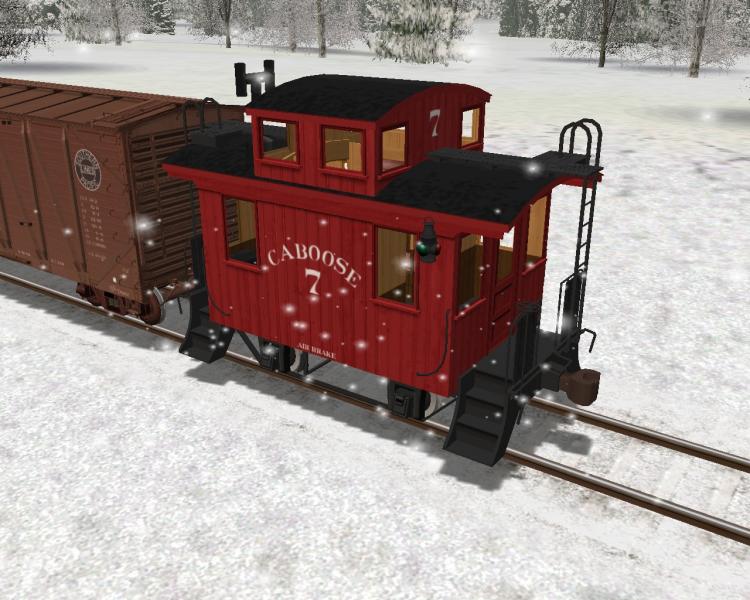
A red crummy in white snow.
A red crummy in white snow.
#36
- Hostler
-
- Group: Status: First Class
- Posts: 75
- Joined: 25-November 08
- Gender:Male
-
Country:
Posted 23 January 2017 - 11:21 AM
 Jonatan, on 23 January 2017 - 08:27 AM, said:

Thanks, Jonatan.
It would be so cool to have a caboose like that to live in. And I know of a great little piece of disused Montana track I would set it on. :D
#37
- Hostler
-
- Group: Status: First Class
- Posts: 75
- Joined: 25-November 08
- Gender:Male
-
Country:
Posted 23 January 2017 - 11:44 AM
Coonskin, on 23 January 2017 - 03:37 AM, said:
Okay, while stuffing my breakfast into my mouth, I took a quick look at Mullan Pass via caltopo.com. I don't see anything on the map that's readily apparent for the alternative pass line.
Do you know if a switchback (or switchbacks) was used? Would you happen to know the routing of the old pass line? Lastly, do you have the USAPhotoMap data needed to get the Mullan Pass area into USAPhotoMaps?
Yeah... I think I could definitely envision funnel stack, wood burning 4-4-0's working mightily to loft the trains over Mullan Pass while the tunnel is being finished! :dance3:
Think you'll be done with your route by next week?
:rotfl:
Do you know if a switchback (or switchbacks) was used? Would you happen to know the routing of the old pass line? Lastly, do you have the USAPhotoMap data needed to get the Mullan Pass area into USAPhotoMaps?
Yeah... I think I could definitely envision funnel stack, wood burning 4-4-0's working mightily to loft the trains over Mullan Pass while the tunnel is being finished! :dance3:
Think you'll be done with your route by next week?
:rotfl:
There is a book I have called Mullan Pass by Bill and Jan Taylor https://www.amazon.c...rds=Mullan+Pass . It is an extensive history of Tunnel Construction and the overhead line including maps, diagrams, and photos that include locomotives that traversed it in those early days. The book proved to be a very worthwhile reference for me. Beyond that the resolution on Google Earth is now good enough that you can trace most of overhead line out. I can email you a kmz file for it if you like or provide a dropbox link in your pm box.
No switchbacks, but the 4.4 percent grade was enough to make things interesting. I guess the German ambassador's car broke loose from the rest of the train on its way to the last last spike proceedings. Fortunately it was stopped before it derailed and no one was hurt. Coupler breaks were quite common on the overhead.
I have all the USA photomaps data, but my folder is over 13 gig in size, so I would probably have to send it to you on a pin drive.
#38
- Hostler
-
- Group: Status: First Class
- Posts: 75
- Joined: 25-November 08
- Gender:Male
-
Country:
Posted 23 January 2017 - 12:15 PM
Pery Scope, on 23 January 2017 - 05:22 AM, said:
This is a nice route. Keep us up to date with more beautiful pictures.
Greetings
Pery Scope
Greetings
Pery Scope
Danke shon, Pery. Will do
#39
- Open Rails Developer
-
- Group: Status: Elite Member
- Posts: 3,723
- Joined: 15-January 04
- Gender:Male
- Location:Eastern Oklahoma
-
Country:
Posted 23 January 2017 - 04:35 PM
batt:
Thanks for the information! Is the book you linked above a different printing of this book:
http://www.ebay.com/...tYAAOSw0OBYKcjm
OR... is the above NOT the same book? If it's not a different printing of the same book as you referenced (instead being an entirely different book by the same author), then I will purchase the book you linked at Amazon.
IMHO, no switchback(s) is a good thing. I have track in place for the switchbacks over NP's Stampede Pass from east of Martin to west of the western portal of the tunnel. I took a serious look at this mini-segment for use as a link 'n pin project route. However, once I began some test operation on it, the sameness of operation sort of did me in. I came to the conclusion I was going to have to build MUCH more of the route (I had the needed NED DEM all the way to Tacoma) in order to have sufficient operational variation/opportunities. I think I recall feeling like I needed to build the entire subdivision from Tacoma eastward well past Stampede Pass (to the end of the sub division at some town that I can't recall) in order to gain what I thought I wanted in regards to operational variety/opportunities.
Thank you much for the offer on the USAPhotoMaps data. Hopefully, using the above book and the digital topographical maps available at caltopo.com, I can create the markers needed for the short route over the pass. If not, then I may take you up on the offer. That so, I would send you a pin drive to fill with data. At 13 gigs, you apparently have the data for the entire NP???
When working on a route, do you wait until the very last to add inter-actives, or are you placing them as you go?
All fer now.
#40
- Member, Board of Directors
-
- Group: Status: Elite Member
- Posts: 8,349
- Joined: 10-September 08
- Gender:Male
- Location:Now in central Arkansas
- Simulator:MSTS & Trainz '04 & Open Rails
-
Country:
Posted 23 January 2017 - 04:47 PM
LOVE that 'boose, Jonatan!!!
http://www.elvastower.com/forums/public/style_emoticons/default/sign_rockon.gif
http://www.elvastower.com/forums/public/style_emoticons/default/oldstry.gif
http://www.elvastower.com/forums/public/style_emoticons/default/sign_rockon.gif
http://www.elvastower.com/forums/public/style_emoticons/default/oldstry.gif