 Log In
 Register Now!
 Help
Help

It's rather slow Walt.
FWIW I've been spending time w/ Qgis wien. It's obviously much faster than Mapwindow. I was able to import USGS 1/9 arc .img files, reform them to the older gis format .tif, save, and import them into DEMEX where I created MSTS terrain... and did so w/o getting lost in all the other functionality these programs all have.
The Goode-Homosoline Projection
Problem statement
Rate Topic:

#31

- Owner Emeritus and Admin
-

- Group: ET Admin
- Posts: 15,366
- Joined: 11-January 04
- Gender:Male
- Location:United States
- Simulator:Open Rails
-
Country:

Posted 15 April 2015 - 09:37 AM
#32
- Open Rails Developer
-

- Group: Status: R.I.P. or just Retired
- Posts: 1,086
- Joined: 28-February 10
- Gender:Male
- Location:Vestal, New York
- Simulator:Open Rails, MSTS
-
Country:
Posted 15 April 2015 - 02:50 PM
 Genma Saotome, on 15 April 2015 - 09:37 AM, said:
It's rather slow Walt.
FWIW I've been spending time w/ Qgis wien. It's obviously much faster than Mapwindow. I was able to import USGS 1/9 arc .img files, reform them to the older gis format .tif, save, and import them into DEMEX where I created MSTS terrain... and did so w/o getting lost in all the other functionality these programs all have.
FWIW I've been spending time w/ Qgis wien. It's obviously much faster than Mapwindow. I was able to import USGS 1/9 arc .img files, reform them to the older gis format .tif, save, and import them into DEMEX where I created MSTS terrain... and did so w/o getting lost in all the other functionality these programs all have.
Well, if I do anything at all with exploring GIS possibilities, I'll do MapWindow and you do Qgis. We can share test cases and each write reports. But I'm not going to do anything at all in that area until I'm finished with Virtual Globes.
#33
- Conductor
-

- Group: Private - Open Rails Developer
- Posts: 322
- Joined: 31-May 11
- Gender:Male
-
Country:
Posted 16 April 2015 - 03:52 PM
Genma Saotome, on 15 April 2015 - 09:37 AM, said:
It's rather slow Walt.
FWIW I've been spending time w/ Qgis wien. It's obviously much faster than Mapwindow. I was able to import USGS 1/9 arc .img files, reform them to the older gis format .tif, save, and import them into DEMEX where I created MSTS terrain... and did so w/o getting lost in all the other functionality these programs all have.
FWIW I've been spending time w/ Qgis wien. It's obviously much faster than Mapwindow. I was able to import USGS 1/9 arc .img files, reform them to the older gis format .tif, save, and import them into DEMEX where I created MSTS terrain... and did so w/o getting lost in all the other functionality these programs all have.
Some of the reasons why QGIS may be faster it's written in C++, along with QT GUI also written in C++. No worries about garbage collection. Of course I assume your comparing apples, both QGIS MapWindonw running on a 64 bit system.
#34
- Owner Emeritus and Admin
-
- Group: ET Admin
- Posts: 15,366
- Joined: 11-January 04
- Gender:Male
- Location:United States
- Simulator:Open Rails
-
Country:
Posted 16 April 2015 - 05:09 PM
BillC, on 16 April 2015 - 03:52 PM, said:
Of course I assume your comparing apples, both QGIS & MapWindow running on a 64 bit system.
Yes.
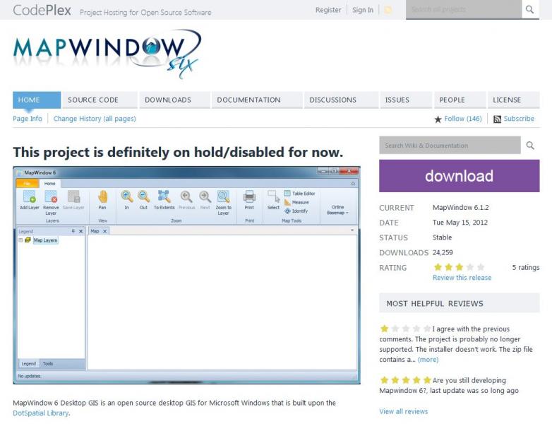
Walt: This may be relevant to your investigation (dated 2012):
#35
- Open Rails Developer
-
- Group: Status: R.I.P. or just Retired
- Posts: 1,086
- Joined: 28-February 10
- Gender:Male
- Location:Vestal, New York
- Simulator:Open Rails, MSTS
-
Country:
Posted 17 April 2015 - 03:20 AM
BillC, on 16 April 2015 - 03:52 PM, said:
Some of the reasons why QGIS may be faster it's written in C++, along with QT GUI also written in C++. No worries about garbage collection. Of course I assume your comparing apples, both QGIS MapWindonw running on a 64 bit system.
The shared comparison I suggested was intended to be only a functional comparison. Obviously, Dave and I are likely to have systems widely different in performance.
If I test the GIS water, it will be with MapWindow. For me, that's the wiser choice. (For example, although I know C++ and have written applications with it, I choose not to go back to it. I wouldn't work with the Unreal engine for the same reason. It's an age and energy thing.) This choice has nothing to do with Open Rails. I'm only offering up the assessment.
#36
- Open Rails Developer
-
- Group: Status: R.I.P. or just Retired
- Posts: 1,086
- Joined: 28-February 10
- Gender:Male
- Location:Vestal, New York
- Simulator:Open Rails, MSTS
-
Country:
Posted 17 April 2015 - 03:30 AM
Genma Saotome, on 16 April 2015 - 05:09 PM, said:
Walt: This may be relevant to your investigation (dated 2012):
Dave, MapWindow Six is kind of like the Open Rails route editor. That release is in the queue for future development. The main thrust of Six will put MapWindow on purely a DotSpatial API base.
The current production release of MapWindow is 4.x. The work now underway is Release 5. That is said to be an effort to put the program on a modern programming practice base. Sound familiar? It should.