Elvas Tower: The Goode-Homosoline Projection - Elvas Tower

Jump to content

Posting Rules

All new threads will be started by members of the Open Rails team, Staff, and/or Admins. Existing threads started in other forums may get moved here when it makes sense to do so.

Once a thread is started any member may post replies to it.
  • 4 Pages +
  • 1
  • 2
  • 3
  • Last »
  • You cannot start a new topic
  • You cannot reply to this topic

The Goode-Homosoline Projection Problem statement Rate Topic: -----

#1 User is offline   Genma Saotome 

  • Owner Emeritus and Admin
  • PipPipPipPipPipPipPipPipPipPipPipPipPip
  • Group: ET Admin
  • Posts: 15,356
  • Joined: 11-January 04
  • Gender:Male
  • Location:United States
  • Simulator:Open Rails
  • Country:

Posted 09 April 2015 - 02:01 PM

Projecting data from a somewhat round earth to a definitively flat map has always been a bit problematic and numerous methods of projection from one to other have been developed, one of which is the Goode-Homosoline Projection. This method was chosen by KUJU for MSTS and using it on a map of the world produces this image:
Attached Image: gh-map.jpg

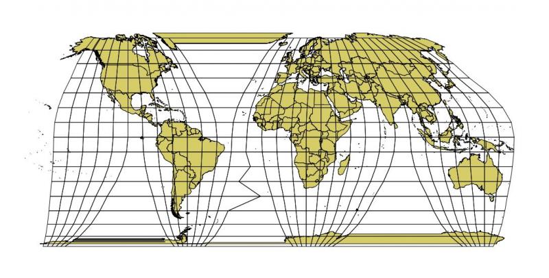
Please note how the longitude lines on the above map vary in direction -- in the area around the Black Sea they're vertical whereas in eastern China and Japan they're at a sharp angle. On the west coast of the US they're also at an angle but one that is opposite that of east Asia. These differences are significant in MSTS because what KUJU did is to start with a map like the above, grab an area of data bounded by the lines you see in this map (a quad of varying angles) and skew the data into a square -- now called a MSTS tile.

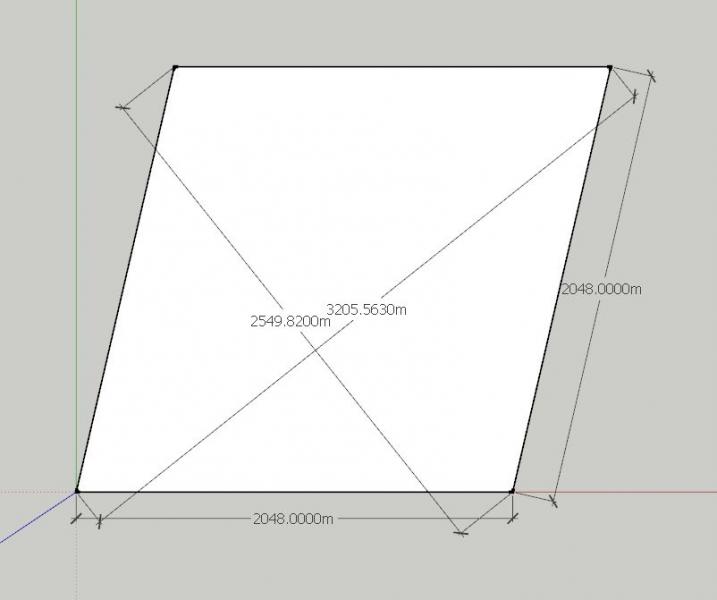
That changes distances on all tiles relative to actual distances on the map. Here is how it works using an example from the US West Coast:

The KUJU selection is in white and the original map data is in gray (note the actual distances from corner to corner):
Attached Image: gh1.jpg


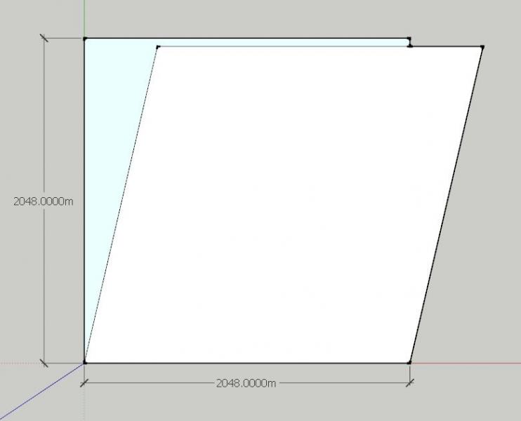
How that selection compares to-be-projected MSTS tile:
Attached Image: gh2.jpg


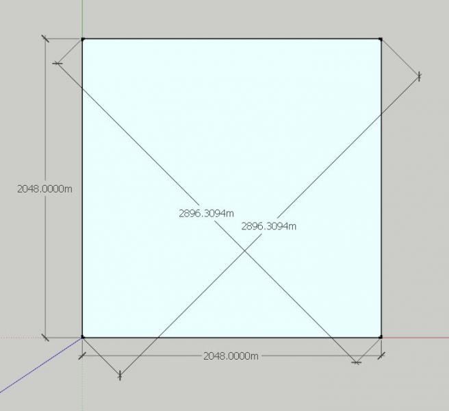
What the distances are within the tile after projection:
Attached Image: gh3.jpg


That is all good and fine if, and only IF everything that goes into MSTS is also taken from a map that uses the Goode-Homosoline projection. Unfortunately, that is most often not the case. ALL of the USGS digital elevation data is projected in other ways... as is google... as is USAPhotoMaps... and AFAIK just about any source of map data one can fine.


Given that reality of source data the end result of mixing projection types is that all MSTS distances measured on the diagonal are all wrong. In this specific example I show above what in the world is ~3200m apart, measured SW to NE is now only ~2900m apart in MSTS. Comparing the NW to SE angle, what in the world is ~2550m apart is now ~2900m apart in MSTS. What is due north/south in a KUJU tile is also wrong -- in reality a north/south alignment should be SW to NE!

IOW in the example shown all distances running SW to NE are ~10% shorter in MSTS; All distances running NW to SE are ~14% longer -- per tile and all North/South alignments are pure fiction. AFAIK, this ruins the use of any available GIS data for roads, rivers, rail lines or imagery (e.g., Google Map images). How great the deviation from reality is is based on where in the world you target.
=====================

Issues:

The first thing is to choose a better projection method. Lindsay had a strong opinion on the matter in favor of a particular Ortho method and wrote it up in one of his posts(I'll have to find it to get the name). My gut feel is we consider that as our first (and perhaps only) candidate.

Second, AFAIK there is no open source equivalent to KUJU's RJE software which creates a quad tree structure for files holding game terrain and related data. To use any alternative to the Goode-Homosoline project will require writing a program from scratch to perform a similar function to the RJE program. Any enhancement of functionality will necessitate changing the file definitions and/or creating new side-by-side files for new features, paired with the old Kuju file format.

Third, AFAIK there is no open source software available to use to project DEM data from any source into any game file. Commerically DEMEX is still available; It's default mode is to project using the Goode-Homosoline method, tho if you fiddle w/ options you can project data using an alternative (and more reasonable ortho) method. DEMEX is as old as MSTS, it leaks memory like a sieve, it crashes, it uses obsolete raster formats to import DEM data -- lots of problems. The choice here is to work with Jeffery to revise DEMEX or write an equivalent program from scratch.

Fourth, if an Ortho projection is the go-forward solution what to do with all of the extant routes using the Goode-Homosoline projection? IMO the correct answer is nothing; IF there is a time when route level migration from MSTS to OR is called for I think the best answer is to assume the MSTS route is correct and not worry about the facts.

#2 User is offline   jtr1962 

  • Fireman
  • Group: Status: Active Member
  • Posts: 178
  • Joined: 13-December 09
  • Gender:Male
  • Country:

Posted 09 April 2015 - 03:13 PM

This explains to me why the distances on a lot of routes are wrong. I noted when using the PRR Eastern Division that NYP to Trenton is short by nearly 5 miles, for example.

I think eventually if we use Ortho projections it might be nice to have a utility which can translate a route from Goode-Homosoline to Ortho. Assuming the MSTS route is correct you would then end up with correct distances between waypoints. The scenery objects and tile textures wouldn't be a major problem although they might end up in slightly different locations relative to the track. The track and roads would be a bigger problem however as they're based on sectional shape files. It would make sense then to use procedural track only for OR routes, and translate the MSTS .tdb to procedural track when migrating routes. I'm guessing that too wouldn't be huge issue except for switches. You might need some procedural definition so the translated switches matched whatever was in the MSTS route.

#3 User is offline   captain_bazza 

  • Chairman, Board of Directors
  • PipPipPipPipPipPipPipPipPipPipPip
  • Group: ET Admin
  • Posts: 13,927
  • Joined: 21-February 06
  • Gender:Male
  • Location:Way, way, way, South
  • Simulator:MSTS & OR
  • Country:

Posted 09 April 2015 - 08:39 PM

Hey, we're not even on that map, I want my money back and substancial damages for personal trauma from discovering I live in New Nowhereland!


Cheers Bazza.

#4 User is offline   captain_bazza 

  • Chairman, Board of Directors
  • PipPipPipPipPipPipPipPipPipPipPip
  • Group: ET Admin
  • Posts: 13,927
  • Joined: 21-February 06
  • Gender:Male
  • Location:Way, way, way, South
  • Simulator:MSTS & OR
  • Country:

Posted 09 April 2015 - 08:49 PM

Testing new keyboad w/ pad.

Cheers Bazza.

#5 User is offline   WaltN 

  • Open Rails Developer
  • Group: Status: R.I.P. or just Retired
  • Posts: 1,086
  • Joined: 28-February 10
  • Gender:Male
  • Location:Vestal, New York
  • Simulator:Open Rails, MSTS
  • Country:

Posted 10 April 2015 - 07:16 AM

View PostGenma Saotome, on 09 April 2015 - 02:01 PM, said:

Issues:

The first thing is to choose a better projection method. Lindsay had a strong opinion on the matter in favor of a particular Ortho method and wrote it up in one of his posts(I'll have to find it to get the name). My gut feel is we consider that as our first (and perhaps only) candidate.

"Ortho"-what?

I spent an hour searching the ET public forum and the only thing I found that could be interpreted as a recommendation by Lindsay (userid Lindsayts for anyone that wants to continue the search) is a last-August recommendation of Transverse Mercator ( TM ). You can read his post to get a characterization of TM versus the special case UTM.

A point I would like to make is that co-equally important to the selection of a projection method (call it X) is the existence of a free or low-cost GIS system that supports conversion of commonly available DEM and "shape" datasets with Projection X. (Shape in this context means things like roads, railways, rivers, etc.) I know that there are people who disagree with me on this, but I think the notion that Open Rails can produce a GIS component that meets route developer requirements is far-fetched. (I think I can say that even without having those requirements in front of me.)

Our only hope, in my opinion, is to survey candidate GIS systems (e.g., Microdem, MapWindow) and hope they support X.

#6 User is offline   cjakeman 

  • Vice President
  • PipPipPipPipPipPipPipPip
  • Group: ET Admin
  • Posts: 2,869
  • Joined: 03-May 11
  • Gender:Male
  • Location:Peterborough, UK
  • Simulator:Open Rails
  • Country:

Posted 10 April 2015 - 11:05 AM

View PostWaltN, on 10 April 2015 - 07:16 AM, said:

Our only hope, in my opinion, is to survey candidate GIS systems (e.g., Microdem, MapWindow) and hope they support X.

Is this link any good? The free GRASS GIS sounds interesting.

Another option is to get advice from a GIS practitioner. GRASS GIS lists a number of contacts.

#7 User is offline   BillC 

  • Conductor
  • Group: Private - Open Rails Developer
  • Posts: 322
  • Joined: 31-May 11
  • Gender:Male
  • Country:

Posted 10 April 2015 - 01:14 PM

View PostWaltN, on 10 April 2015 - 07:16 AM, said:

"Ortho"-what?

..............

Our only hope, in my opinion, is to survey candidate GIS systems (e.g., Microdem, MapWindow) and hope they support X.


Walt,
Listed below are research you have done in the past on this subject:

http://www.elvastowe...ew/page__st__60 #61 #63
http://www.elvastowe...ew/page__st__80 #83 #84

Dr. Zigler appears to be a domain export for using GIS data for railroad modeling. Giving his low cost product and using UTM as the new projection for OR. With his frequent update's and on going support, using UTM in OR, could result with him supporting OR.

This link http://www.wwu.edu/h...S_to_ArcGIS.htm discusses converting GPS data to other projections using ArcGis. ArcGis is a high cost commercial product, however an open source version QGIS is available which use's GRASS as a sub component.

In doing a google search on What type of map projection does Google use for Google Maps results with a reply that the
Mercator projection is used. This being the case then conversion would be necessary for NED height data.

IMHO for OR world editor, both a better GIS projection system is needed, preferably UTM. However along with that the
Goode-Homosoline would also need to be supporeted, ie. two different modes. Instead of getting hang up on the interface, use the
existing the existing one in the interim. Users are know the current system along documented support. What is frustrating are the bugs
that result in destroying edits, and the need to still use train.exe .


#8 User is offline   Genma Saotome 

  • Owner Emeritus and Admin
  • PipPipPipPipPipPipPipPipPipPipPipPipPip
  • Group: ET Admin
  • Posts: 15,356
  • Joined: 11-January 04
  • Gender:Male
  • Location:United States
  • Simulator:Open Rails
  • Country:

Posted 10 April 2015 - 03:10 PM

View PostWaltN, on 10 April 2015 - 07:16 AM, said:

"Ortho"-what?


Sorry about that... my ignorance on display.

FWIW I am playing around with QGIS -- another open source GIS program. I'm just tying very some simple tasks -- can it read and display a USGS .img file -- their current standard for elevation data (Yes) and convert it to a .tif that DEMEX can read (seems to). Havn't gotten very far on other things but it looks promising.

#9 User is offline   Genma Saotome 

  • Owner Emeritus and Admin
  • PipPipPipPipPipPipPipPipPipPipPipPipPip
  • Group: ET Admin
  • Posts: 15,356
  • Joined: 11-January 04
  • Gender:Male
  • Location:United States
  • Simulator:Open Rails
  • Country:

Posted 10 April 2015 - 03:22 PM

View PostBillC, on 10 April 2015 - 01:14 PM, said:


Dr. Zigler appears to be a domain export for using GIS data for railroad modeling. Giving his low cost product and using UTM as the new projection for OR. With his frequent update's and on going support, using UTM in OR, could result with him supporting OR.


Who is Dr. Zigler?

#10 User is offline   BillC 

  • Conductor
  • Group: Private - Open Rails Developer
  • Posts: 322
  • Joined: 31-May 11
  • Gender:Male
  • Country:

Posted 10 April 2015 - 06:05 PM

View PostGenma Saotome, on 10 April 2015 - 03:22 PM, said:

Who is Dr. Zigler?


Dr. Ziegler is the author of TransDem. Here is a link to the WebSite. On the webSite there is an active forum here.

  • 4 Pages +
  • 1
  • 2
  • 3
  • Last »
  • You cannot start a new topic
  • You cannot reply to this topic

1 User(s) are reading this topic
0 members, 1 guests, 0 anonymous users