 Weter, on 18 July 2021 - 10:37 AM, said:
BTW, are your icons links to local disc manual, or to online resource?
The (i) icons take you to
an on-line copy of the manual which is automatically kept in step with the PDF version.
R H Steele, on 18 July 2021 - 10:53 AM, said:
Yep, been using 70% forever...just checked, had not thought about it at all, until you posed the question. I scroll up or down now, slightly to see more of the cab, if necessary. If there's a reasonable option to get rid of it...I can adapt.
Thanks for being flexible about this.
Please try 0% stretch and Ryan's alternative Ctrl+1 too and see how you get on.
-----------------------------------------------
Perhaps we should consider these next 2 options together:
They seem fine to me.
Are the following Manual entries OK?
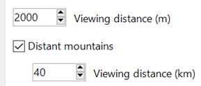
6.3.10. Viewing distance
This option defines the maximum distance at which terrain is displayed. At higher distances Distant Mountains will be displayed (see below). This parameter increases CPU and GPU load. Also, some routes are optimized for the standard MSTS maximum viewing distance (2000m).
6.3.11. Distant mountains
Distant mountains are supported in a way that is compatible with MSTS. Distant mountains are present in the route if it has a folder called LO_TILE. You may turn the feature on by checking the Distant Mountains checkbox. In addition to MSTS capability, you can select the viewing distance of the distant mountains.
 Log In
 Register Now!
 Help
Help


