 Log In
 Register Now!
 Help
Help
How do I change an existing texture from TERRAIN.ACE to another Terrtex for the Whole Tile using ROUTE EDITOR
Thanks
Page 1 of 1
Change existing Tile
Route Editor
Rate Topic:

#1

- Fireman
-

- Group: Status: Active Member
- Posts: 183
- Joined: 15-September 16
- Gender:Male
- Location:New Zealand
- Simulator:OR
-
Country:

Posted 23 January 2024 - 01:22 AM
#2
- Engineer
-

- Group: Status: Contributing Member
- Posts: 548
- Joined: 04-April 14
- Gender:Male
- Simulator:MSTS & OR
-
Country:

Posted 23 January 2024 - 05:30 AM
Interesting question. In my opinion, this is not possible for a single tile in RE.
To change the terrain texture for a single tile, the only thing I can think of is to manipulate the corresponding *.t file in the tiles folder. I have just unpacked a t-file with the help of Route_Riter and I could then change the "terrain_texslot" entries in it:
The t-file must then be re-compressed again. Both MSTS and OR can only handle compressed t-files.
Remains to find out which t-file corresponds to which w-file.
All in all, it's a tricky business I would say.
To change the terrain texture for a single tile, the only thing I can think of is to manipulate the corresponding *.t file in the tiles folder. I have just unpacked a t-file with the help of Route_Riter and I could then change the "terrain_texslot" entries in it:
SIMISA@@@@@@@@@@JINX0txt______

terrain (
	terrain_errthreshold_scale ( 1 )
	terrain_water_height_offset ( 0 0 0 0 )
	terrain_alwaysselect_maxdist ( 0 )
	terrain_samples (
		terrain_nsamples ( 256 )
		terrain_sample_rotation ( 0 )
		terrain_sample_floor ( -25 )
		terrain_sample_scale ( 0.00326538 )
		terrain_sample_size ( 16 )
		terrain_sample_ybuffer ( _11dc4b0_y.raw )
		terrain_sample_ebuffer ( _11dc4b0_e.raw )
		terrain_sample_nbuffer ( _11dc4b0_n.raw )
	)
	terrain_shaders ( 2
		terrain_shader ( DetailTerrain
			terrain_texslots ( 2
				terrain_texslot ( terrain.ace 1 0 )
				terrain_texslot ( microtex.ace 1 1 )
			)
			terrain_uvcalcs ( 2
				terrain_uvcalc ( 1 0 0 0 )
				terrain_uvcalc ( 2 0 1 32 )
			)
		)
		terrain_shader ( AlphaTerrain
			terrain_texslots ( 1
				terrain_texslot ( terrain.ace 1 0 )
			)
			terrain_uvcalcs ( 1
				terrain_uvcalc ( 1 0 0 0 )
...
The t-file must then be re-compressed again. Both MSTS and OR can only handle compressed t-files.
Remains to find out which t-file corresponds to which w-file.
All in all, it's a tricky business I would say.
#3
- Superintendant
-

- Group: Status: Elite Member
- Posts: 1,855
- Joined: 19-December 09
- Gender:Male
- Location:South of here
- Simulator:ORMG
-
Country:

Posted 23 January 2024 - 06:16 AM
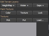
In the TSRE F2 menu "Pick" lets you pick the texture of a tile anywhere on the route and "Put" lets you put that texture on any tile in the route.
You can also "Load" a texture from a file and "Put" it where you want.
Randy
You can also "Load" a texture from a file and "Put" it where you want.
Randy
#4
- Engineer
-
- Group: Status: Contributing Member
- Posts: 548
- Joined: 04-April 14
- Gender:Male
- Simulator:MSTS & OR
-
Country:
Posted 23 January 2024 - 11:00 AM
Because I understood NZ_JOHN want to know how it could work with the MSTS RE, I had described it as above.
It maybe easier in the TSRE5. However, in TSRE5 I was only able to make changes for individual grid squares in the grid of a tile - at least with the pick-put method.
The textures of the grids you can easily change in MSTS RE too.
It maybe easier in the TSRE5. However, in TSRE5 I was only able to make changes for individual grid squares in the grid of a tile - at least with the pick-put method.
The textures of the grids you can easily change in MSTS RE too.
#5
- Fireman
-
- Group: Status: Active Member
- Posts: 183
- Joined: 15-September 16
- Gender:Male
- Location:New Zealand
- Simulator:OR
-
Country:
Posted 23 January 2024 - 03:23 PM
Thanks
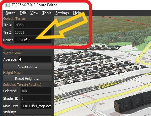
Im using TSRE5 V0.7.012 Route Editor
Rather complicated working out which *.t file to use as there is no reference to tile in there (Like 2536 10013).
So I can put up changing the necessary sub Tites within each
BUT
how can I change the default when creating a new TILE?
Im using TSRE5 V0.7.012 Route Editor
Rather complicated working out which *.t file to use as there is no reference to tile in there (Like 2536 10013).
So I can put up changing the necessary sub Tites within each
BUT
how can I change the default when creating a new TILE?
#6
- Fireman
-
- Group: Status: Active Member
- Posts: 183
- Joined: 15-September 16
- Gender:Male
- Location:New Zealand
- Simulator:OR
-
Country:
Posted 23 January 2024 - 04:20 PM
 Weter, on 23 January 2024 - 03:27 PM, said:
Hello, John.
Tile numbers are shown in NaviWindow, IIRC
Tile numbers are shown in NaviWindow, IIRC
I know they are in the NAVIWINDOW but how does that tell me which *.T file name
#7
- Engineer
-
- Group: Status: Contributing Member
- Posts: 548
- Joined: 04-April 14
- Gender:Male
- Simulator:MSTS & OR
-
Country:
Posted 23 January 2024 - 09:00 PM
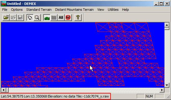
I can only think of DEMEX, which displays the tile files by hovering over the loaded tiles of a route. At least you can see a relation between the lat/lon coordinates and the tile files, but regretfully no direct display of the X/Y coordinates, like e.g. -5578/14960:
#8
- Member, Board of Directors
-

- Group: ET Admin
- Posts: 6,985
- Joined: 01-June 20
- Gender:Not Telling
- Simulator:ORTS
-
Country:

Posted 24 January 2024 - 10:16 AM
@John
I somwhow did that, finding excessive tiles and deleting their files manually.
If I remember - I'll tell You.
Simplest way: modify terrain on tile in question and try to quite TSRE - it then will ask You:
File(s) <their names will be listed) are modified... Exit with/without saving them?
EVRIKA (from Greek - Just have found that!)
Page 1 of 1