 Log In
 Register Now!
 Help
Help

Hello All .. !!
I have checked two routes .., one on western side and other on eastern side .., and the OpenRailwayMap is pretty accurate. No obvious distortions or error`s. so its good from India .. :)
OpenRailway map added to Open Rail - Web Interface
Rate Topic:

#41

- Engineer
-

- Group: Posts: Contributing Member
- Posts: 606
- Joined: 01-March 15
- Gender:Male
- Simulator:Open Rails
-
Country:

Posted 23 December 2022 - 05:36 AM
#42
- Executive Vice President
-

- Group: ET Admin Group
- Posts: 3,031
- Joined: 03-May 11
- Gender:Male
- Location:Peterborough, UK
- Simulator:Open Rails
-
Country:

Posted 24 December 2022 - 12:14 PM
 Hamza97, on 23 December 2022 - 05:36 AM, said:
I have checked two routes .., one on western side and other on eastern side .., and the OpenRailwayMap is pretty accurate. No obvious distortions or error`s. so its good from India ..
Good news, then. Thanks, Hamza.
#43
- Owner Emeritus and Admin
-
- Group: ET Admin Group
- Posts: 15,661
- Joined: 11-January 04
- Gender:Male
- Location:United States
- Simulator:Open Rails
-
Country:

Posted 02 April 2023 - 11:34 AM
When MSTS was rather new a 3rd party program called DEMEX was released for the purpose of projecting DEM data into tiles of any route. It used the Goode-Homosoline projection, as did the game. In much later release there was an option to not use the G-H projection and instead use... something else. I did that on one very short route that I continue to build and experimentally did the same on a couple other investigation routes. On the later I found substantial relocations of terrain from one tile to another, sometimes several tiles away. I have no idea if there is any metadata anywhere to indicate that G-H is not being used, nor do I have any idea how many other routes, if any, are the same as what I described here.
#44
- Apprentice
-
- Group: Posts: Switchman
- Posts: 9
- Joined: 23-May 23
- Gender:Male
- Simulator:Open Rails
-
Country:
Posted 21 February 2025 - 02:27 PM
It kind of confuses me.
#45
- Owner Emeritus and Admin
-
- Group: ET Admin Group
- Posts: 15,661
- Joined: 11-January 04
- Gender:Male
- Location:United States
- Simulator:Open Rails
-
Country:
Posted 21 February 2025 - 11:02 PM
Quote
It kind of confuses me.
Welcome to MSTS/Open Rails.
This is a Goode-Homosoline map (click on image for full size):
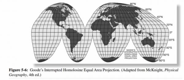
Note that there are very few squares... most of the shapes have the top or bottom lines skewed left or right. OTOH, MSTS (and OpenRails) uses squares (a.k.a. as tiles) to hold the terrain data. By some mathematical magic the skewed quadrilaterals are unskewed and turned into squares -- but everything about the latitude and longitude remains in the data. So when you use any sort of map to trace perpendicular lines line (e.g., a right angle road intersection) and get that trace into your route (called markers) it isn't a a right angle line anymore... it is the same angle as the side of the skewed map. On one of my routes the trace of one road is 77d/103d where it hits the other road instead of 90d/90d. I don't know why it works out this way but it does.
If you compare the quadrilaterals of Japan and Australia you'll see how the above fact can play havoc in Japanese routes but not so much in eastern Australia.
This is the nonsensical mess we've been living with for more than 20 years. There has been loads of thought put into using some other map projection, one better suited to our needs. I know the last version of Demex could do something else and I know Goku was experimenting with something but I do not recall what it was.
#46
- Member, Board of Directors
-
- Group: ET Admin Group
- Posts: 8,931
- Joined: 01-June 20
- Gender:Not Telling
- Simulator:ORTS
-
Country:

Posted 21 February 2025 - 11:08 PM
Thanks for explanation.
The drawing shows clearly, how Author tried to find some compromise, making less distortion above more important areas, leaving greater distortion to oceans or less important (to his purposes) regions.
The drawing shows clearly, how Author tried to find some compromise, making less distortion above more important areas, leaving greater distortion to oceans or less important (to his purposes) regions.
#47
- Apprentice
-
- Group: Posts: Switchman
- Posts: 9
- Joined: 23-May 23
- Gender:Male
- Simulator:Open Rails
-
Country:
Posted 07 March 2025 - 12:53 PM
The application is kind of complicated.