 Log In
 Register Now!
 Help
Help

Great work, Dave. I hope we see a few more like this. I'm trying to get a similar feel with the UP Gila as it crosses Arizona.
Bit between the teeth again
Rate Topic:

#11

- Waste Disposal Engineer
-

- Group: Private - Open Rails Developer
- Posts: 1,578
- Joined: 30-October 10
- Gender:Male
- Simulator:ORTS
-
Country:

Posted 08 September 2014 - 10:07 AM
#12
- Superintendant
-

- Group: Status: Elite Member
- Posts: 1,085
- Joined: 18-January 13
- Gender:Not Telling
- Location:Pacific Time
- Simulator:Mostly ORTS these days
-
Country:
Posted 08 September 2014 - 11:28 AM
Glad to see you're back at work on Cal-P. I also have to comment on the realistic-looking water. While the Bay can look blue occasionally, it usually doesn't. As far as the rivers go, you have exactly the right color.
Is it possible to have a "rough" texture in MSTS/ORTS? I've seen this in other routes too. Going through the marshes with flat green tiles around doesn't look very "marshy" but adding hundreds (or thousands?) of "bushes" to represent the marsh plants is a pain and probably a FPS-killer.
The SF skyline would seem like another application for "distant mountains" as seen from the East Bay, though a tad closer than Mt. Tam.
Again, thanks! :sign_welcome:
#13
- Engineer
-

- Group: Status: Inactive
- Posts: 546
- Joined: 11-December 08
- Gender:Male
-
Country:

Posted 08 September 2014 - 12:04 PM
 Genma Saotome, on 07 September 2014 - 05:34 PM, said:
Bob, I have tried that... multiple variations too. I have tried different tertex art under it all too.
Maybe it is the art I have to work with but it seems I'm never very pleased with how it looks in all places. I might have one that's fine for the river but terrible for the marshland. A different one looks good for the bay but is all wrong for the river. It's frustrating.
Maybe it is the art I have to work with but it seems I'm never very pleased with how it looks in all places. I might have one that's fine for the river but terrible for the marshland. A different one looks good for the bay but is all wrong for the river. It's frustrating.
Comments : I find that attempting to get water tables conform to what you have in mind, to be very wasteful in terms of time / energy / aggravation , as you can make endless changes, and seemingly end up with little, or no results, derived from those ( endless )changes. I must have wasted at least 2 or 3 entire weekends..., just "toying around" with water tables, with hardly anything worthwhile to show for.
If anything may help, I have the 3 layers for the water tables, as very transparent , at the alpha channel , and found most of the "impact" , overall, actually, is generated by the Terrtex used immediately underneath the enabled water table patches.
Even as of last evening, I did revise an ocean bottom terrtex ace texture, which already was of a "sand" color, with one about 10% lighter ( whiter ) , in shade, and Bam ! ... this single ace texture change , all-by-itself , just-about changed everything , and very noticeably.
For pretty much any water surfaces, outside of the Ocean itself, you may get better results, and a much greater degree of control, simply using "water plates" ( 2 dimensional squares or rectangular sheets ) . Even fast-flowing "rapids" may look better using flat / 2D / static , world object "water plates" .
The "animated-GIF" version of water tables, on the other hand , seems just-about mandatory, for such as the ocean, or when "waves" are definitely part of the nature of the water surface.
I'd save the ( animated GIF ) water tables for the Ocean, for their convenience, and work with world object flat water plates, for all other water surfaces .
Jean Brisson
#14
- Foreman Of Engines
-

- Group: Status: First Class
- Posts: 869
- Joined: 15-February 07
- Gender:Male
- Location:Lancaster, Ohio, USA
- Simulator:MSTS, OpenRails
-
Country:
Posted 08 September 2014 - 12:57 PM
Sorry to hear that, Dave. I thought I might have been onto a good idea, but seems you already thought of it! I do hope you find something that works for you. It is amazing what has been done so far with this old sim. Keep up the great work, it looks fantastic!
Bob :)
Bob :)
#15
- Owner Emeritus and Admin
-

- Group: ET Admin
- Posts: 15,350
- Joined: 11-January 04
- Gender:Male
- Location:United States
- Simulator:Open Rails
-
Country:
Posted 08 September 2014 - 04:28 PM
Jean, you are right about poorly invested time but it seems to be an itch I always scratch anyway. I've tried 2, 3, even 4 layers of textures, varying color, opacity. Different tertex art under it all. No joy (yet).
One thing that may be a factor is in most places the terrain is a full 10-11m below the top water layer, something that does factor in when using semi-transparent water .aces.
Something else I'll mention... I took full advantage of the MSTS feature to vary water height by season (via the seasonal .env files). For the Cal-P winter water is distinctly murkier, reflecting the extra flow, and I raised its altitude to reflect a correct high tide -- mud flats disappear and much of the Solono Marshes are flooded. Unfortunately the same feature has not yet been implemented in OR. I do hope it is added in some way because the tidal effect is pretty cool.
Here's an ancient screenshot from MSTS that shows the flood:
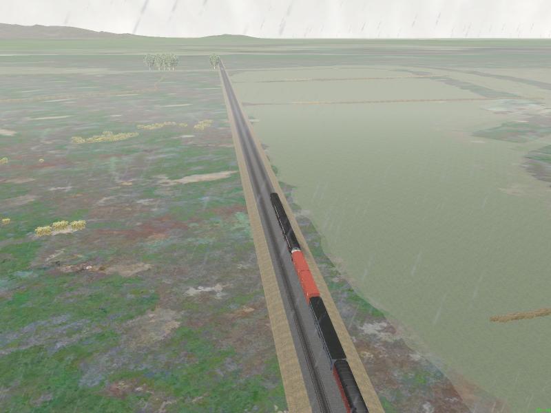
Almost all of that water is underground at "low tide" / Summer.env
One thing that may be a factor is in most places the terrain is a full 10-11m below the top water layer, something that does factor in when using semi-transparent water .aces.
Something else I'll mention... I took full advantage of the MSTS feature to vary water height by season (via the seasonal .env files). For the Cal-P winter water is distinctly murkier, reflecting the extra flow, and I raised its altitude to reflect a correct high tide -- mud flats disappear and much of the Solono Marshes are flooded. Unfortunately the same feature has not yet been implemented in OR. I do hope it is added in some way because the tidal effect is pretty cool.
Here's an ancient screenshot from MSTS that shows the flood:
Almost all of that water is underground at "low tide" / Summer.env
#16
- Engineer
-
- Group: Status: Inactive
- Posts: 546
- Joined: 11-December 08
- Gender:Male
-
Country:
Posted 09 September 2014 - 12:21 PM
Genma Saotome, on 08 September 2014 - 04:28 PM, said:
...One thing that may be a factor is in most places the terrain is a full 10-11m below the top water layer, something that does factor in when using semi-transparent water .aces....
Feedback : Depending on how deep below the water table top layer, your terrain may be, this will expose either only the top layer of the water table, or top 2 / top 3, etc ..., and this ( in my case ) mostly affects how dark... the overall water table rendition will be , according to terrain depth below the water table top layer.
My top layer-only, would render as very light "powder blue" ( I have no appetite to fine-tune it any further... ), with two layers exposed, I end up with the "default" I prefer, leaning towards a teal blue shade, and 3 layers exposed, this all turns into a solid and deep "Cobalt" blue, and at that 3rd layer being exposed, loses all the "animated GIF" features .
My Terrain ( underneath the water table areas ), is deliberately "flattened out" very evenly, at about 1.5 meters below the top layer of the water table . You can also "edit" the amount of "air space", in-between the water table layers.
As far as the seasonal water table height variations, I was completely unaware of this .
Further to that , Yes, I can totally relate to water levels for such as marshes, and especially coastal "mud flats", and have seen extremes where you can either walk almost a mile or two from a beach , before dipping your toes in water, or , alternatively, see water rise so much as to just-about flood berms and "seawalls".
Depending on the Route project , yes, I can see the need / desire, to experiment far beyond the conventional, especially considering such marshes and mud flats, in the Bay area, as their presence is overpowering at times ( in the context of railroads running through such areas ).
I would be very curious to see how this is developing on your project .
Jean Brisson
#17
- Apprentice
-

- Group: Status: Switchman
- Posts: 7
- Joined: 01-July 14
- Gender:Male
- Location:DC Metro area
- Simulator:MSTS, TS2014, Open Rails
-
Country:
Posted 02 March 2015 - 06:45 AM
Delighted to hear that the Cal-P project continues, and terrific screenshots. I'm a hopeless Bay Area railroading addict.
Becoming again inspired to re-learn the Route Editor and do some early Marin County, but I'll save that for a more appropriate venue.
Thanks for posting!
Becoming again inspired to re-learn the Route Editor and do some early Marin County, but I'll save that for a more appropriate venue.
Thanks for posting!