Elvas Tower: The Loop - Elvas Tower

Jump to content

Page 1 of 1
  • You cannot start a new topic
  • You cannot reply to this topic

The Loop Filling in the gaps Rate Topic: -----

#1 User is offline   Genma Saotome 

  • Owner Emeritus and Admin
  • PipPipPipPipPipPipPipPipPipPipPipPipPip
  • Group: ET Admin
  • Posts: 15,354
  • Joined: 11-January 04
  • Gender:Male
  • Location:United States
  • Simulator:Open Rails
  • Country:

Posted 25 April 2013 - 08:09 PM

Downtown Chicago has long been called "the Loop" for ~100 years or so -- named after a circle of elevated commuter rail that ringed downtown. The commuter rail -- and the name -- remain in use today.

What I'm trying to do with The Loop in the Goose Island project is provide a scenic background to the areas where trains will be operated. Some future incarnation could include the elevated commuter rail but that's not in my plans but perhaps someone else will want to do that. The Loop could also be expanded just a few blocks to the south and include two additional passenger terminals -- Grand Central and Dearborn, and with further expansion the tracks entering those stations... again, not in my plans bu7t, again, perhaps someone else will want to do that.

So here's what I've plugged in so far, as seen from the MILW bridge that crosses the Chicago River near Wolf Point... this is looking southeast at the Loop:
Attached Image: Clipboard0044.jpg

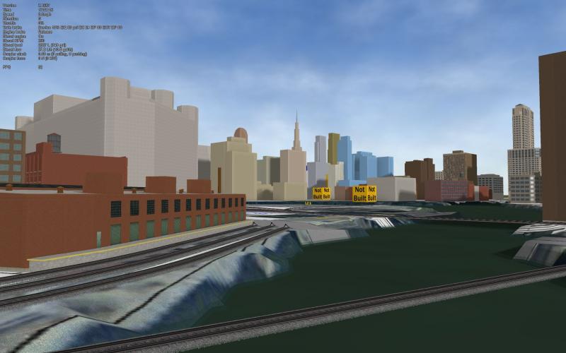
What I've accomplished is about 2 streets worth of buildings as measured from the river's edge. I want to convey that the area is both built up and crowded. As I'm a sticker for accuracy everything shown is patterned from the Sanborn maps, 1941-51, meaning the models do have the right shape and height that the real buildings had.

The way I work is to get the basic shape modeled... at some later time I'd do basic textures, and later still finish w/ the right detils (so these are very preliminary).

#2 User is offline   captain_bazza 

  • Chairman, Board of Directors
  • PipPipPipPipPipPipPipPipPipPipPip
  • Group: ET Admin
  • Posts: 13,927
  • Joined: 21-February 06
  • Gender:Male
  • Location:Way, way, way, South
  • Simulator:MSTS & OR
  • Country:

Posted 25 April 2013 - 10:29 PM

That's a great looking skyline, Dave.

Cheers Bazza

#3 User is offline   Bernie 

  • Vice President
  • Group: Status: Elite Member
  • Posts: 2,774
  • Joined: 06-March 10
  • Gender:Male
  • Location:Massachusetts
  • Simulator:MSTS
  • Country:

Posted 26 April 2013 - 06:18 AM

This is where being a stickler and a highly accomplished modeler really shows, this latest update looks great! :sweatingbullets: I can't wait to see how this same shot looks once you finish texturing the buildings! :good:

#4 User is offline   Noisemaker 

  • Executive Vice President
  • Group: Status: Elite Member
  • Posts: 3,354
  • Joined: 02-August 07
  • Gender:Male
  • Country:

Posted 26 April 2013 - 12:54 PM

Looking great Dave! ;) Are you going to build all the bridges too, or go with Ron Picardi's or the like? They're pretty well all iron/steel work underneath aren't they? Make your buildings seem like nothing after awhile. ;)

I've heard of Dearborn, MI - but a Dearborn station in Chicago as well? Any connection between the two? Michigan Central or something?

#5 User is offline   Genma Saotome 

  • Owner Emeritus and Admin
  • PipPipPipPipPipPipPipPipPipPipPipPipPip
  • Group: ET Admin
  • Posts: 15,354
  • Joined: 11-January 04
  • Gender:Male
  • Location:United States
  • Simulator:Open Rails
  • Country:

Posted 26 April 2013 - 03:10 PM

View PostNoisemaker, on 26 April 2013 - 12:54 PM, said:

Looking great Dave! ;) Are you going to build all the bridges too, or go with Ron Picardi's or the like? They're pretty well all iron/steel work underneath aren't they? Make your buildings seem like nothing after awhile. ;)

I've heard of Dearborn, MI - but a Dearborn station in Chicago as well? Any connection between the two? Michigan Central or something?


I'm going to try a bridge, just to see how it goes. Here's the Division St bridge to Goose Island (on the right):
Attached Image: Division Ave to Goose Island.jpg

There's plenty of data & photos in the HABS/HAER collection so I'll have good info to work from.

WRT Dearborn Station... Ft Dearborn is the original name for Chicago.

#6 User is offline   CrisGer 

  • Member, Board of Directors
  • PipPipPipPipPipPipPipPipPipPip
  • Group: ET Admin
  • Posts: 5,358
  • Joined: 06-October 09
  • Gender:Male
  • Location:Colorado and California
  • Simulator:MSTS OR
  • Country:

Posted 26 April 2013 - 03:36 PM

looking great Dave, hopefully if i run fast with my studies with TSM and SUP i will be able to help populate the city...Ron has some great bridges some of which can be adjusted for Chicago, i know those bridges well and some of them are very nice in design ...so much to enjoy about that location....

that area was origianlly swamp land and took a lot of draining and work to make it somewhat stable but a lot of the big buildings needed deep caissons to make them stable. I see some very familiary structures there.

#7 User is offline   Noisemaker 

  • Executive Vice President
  • Group: Status: Elite Member
  • Posts: 3,354
  • Joined: 02-August 07
  • Gender:Male
  • Country:

Posted 27 April 2013 - 06:43 PM

That's how I pictured them Dave, either above and/or below. Pretty intricate work, and better you than me. :discuss_gathering: But if you use Ron Picardi's bridge textures at least, at may speed up the process and be easy on the polys as well.

Page 1 of 1
  • You cannot start a new topic
  • You cannot reply to this topic

1 User(s) are reading this topic
0 members, 1 guests, 0 anonymous users