 Log In
 Register Now!
 Help
Help


I apologise for the size of the screen shot as scaling it down lost to much detail.
Note the trees in the distance on the ridge line.
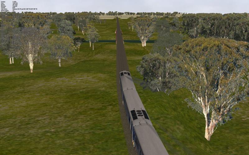
The route used is the latest version of TA_VR_NE_1950s, (The main NE line to Sydney NSW from Melbourne in Vic, it appears to be no longer avaible). What was done I edited the LOD distance values of the almost all the trees. Most had two LODs, there default distance values being 2000 and 500 these were changed to 4000 and 1500. Trees below 10 metres in height were left at the default. Four trees were not done as zipper would not uncompress them. The total number done was 36 trees out of a possible 45 to 50 ( 4 not done as above the others below 10 metres in height).
The display distance was set to 4000 metres, the route has no distant mountains. The screen shot as taken just before the line cross's over the Goulburn river just south of Seymour. Normally one can see the trees being drawn on the rising ground in the distance. There was almost no sign of trees appearing out of thin aire (good!!!!!). I unfortunately did not take a note of the frame rate but it appears to have __VERY__ little effect though. Note the frame rate, 165 fps, this around what one would expect at this point before the experiment.
My initial judgement is this is a significant improvement.
I wonder if it would be worthwhile for OR to ignore the LOD distance values in the shape file and calculate there own based on the objects height from its SD file. On my system (monitor 2560x1600, viewing angle set to 26 degrees) a loading distance based on between 250 to 300 (Note 1) of the objects height has to be looked for to be seen. This value could be user set in the options menu to control the loading distance.
Note 1: Say 1800 metres for a 6 metre high telegraph pole along side the line, I found one can see these being drawn but one does have to LOOK for the effect.
Lindsay
Mass editing LOD values is __REAL__ pain I may say.............


