 Log In
 Register Now!
 Help
Help

Just want to show my thanks and appreciation of the early development of a simple fluid track chart that generates a grade profile that corresponds with a chosen path. This is quite useful for learning a route "lay of the land" whats up ahead as far as grades go. Looks almost like reading actual railway track profiles :buffalobill:
This is awesome for a track chart geek that likes to print off his own paper charts to follow along and keep it realistic without relying on the F5Hud or Track Monitor. Looking forward to how this turns out... Maybe the inclusion of speedlimits, actual mile post,control points, siding and station name signs... The curve data on the bottom of the screen is a nice touch.
I find it neat checking out the track profile that is generated of a custom route that I am working on and how it compares to actual track charts that I am working from gives me confidence that I am on the "Right Track" PI as far as the operational feel goes.
Trackviewer Track Charts
Trackviewer Track Charts
Rate Topic:

#1

- Apprentice
-

- Group: Status: Dispatcher
- Posts: 22
- Joined: 29-December 14
- Simulator:Open Rails
-
Country:

Posted 05 June 2015 - 04:12 AM
#2
- Owner Emeritus and Admin
-

- Group: ET Admin
- Posts: 15,341
- Joined: 11-January 04
- Gender:Male
- Location:United States
- Simulator:Open Rails
-
Country:

Posted 05 June 2015 - 08:30 AM
Where is the command for this?
#3
- Fireman
-

- Group: Status: Active Member
- Posts: 179
- Joined: 28-December 13
- Gender:Male
- Simulator:ORTS
-
Country:

Posted 05 June 2015 - 08:44 AM
Genma,
Good to see you back again in normal posts.
I am not sure exactly what you are asking in regards to 'command'. I am pretty sure the charts that TSCraftman means are the ones you requested in http://www.elvastowe...for-trackviewer and which I am developing.
I am finalizing adding station names, location of reversal and stop points, as well as the possibility to show broken paths anyway.
I will consider mileposts and speedlimits. But at some point there also needs to be a way to select or deselect these.
Jeroen.
#4
- Executive Vice President
-
- Group: ET Admin
- Posts: 4,862
- Joined: 07-February 13
- Gender:Male
- Location:Leoben, Styria, Austria, Europe
- Simulator:ORTS / MSTS
-
Country:

Posted 05 June 2015 - 08:46 AM
You need to load a path first, then select "Show Chart (Under Development" in the ""Path-Editor" drop-down menu in the top menu bar.
Cheers, Markus
Cheers, Markus
#5
- Waste Disposal Engineer
-

- Group: Private - Open Rails Developer
- Posts: 1,574
- Joined: 30-October 10
- Gender:Male
- Simulator:ORTS
-
Country:
Posted 05 June 2015 - 09:03 AM
 JeroenP, on 05 June 2015 - 08:44 AM, said:
Genma,
Good to see you back again in normal posts.
I am not sure exactly what you are asking in regards to 'command'. I am pretty sure the charts that TSCraftman means are the ones you requested in http://www.elvastowe...for-trackviewer and which I am developing.
I am finalizing adding station names, location of reversal and stop points, as well as the possibility to show broken paths anyway.
I will consider mileposts and speedlimits. But at some point there also needs to be a way to select or deselect these.
Jeroen.
Good to see you back again in normal posts.
I am not sure exactly what you are asking in regards to 'command'. I am pretty sure the charts that TSCraftman means are the ones you requested in http://www.elvastowe...for-trackviewer and which I am developing.
I am finalizing adding station names, location of reversal and stop points, as well as the possibility to show broken paths anyway.
I will consider mileposts and speedlimits. But at some point there also needs to be a way to select or deselect these.
Jeroen.
Would you consider toggling markers as well? More and more, Track Viewer has become my replacement for using Mosaic to preview terrtex and overall route progress.
#6
- Fireman
-
- Group: Status: Active Member
- Posts: 179
- Joined: 28-December 13
- Gender:Male
- Simulator:ORTS
-
Country:
Posted 08 June 2015 - 11:38 AM
Dear all
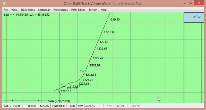
I added an initial version showing mile markers and speed limits.
For long routes the mile markers are on top of each other. Perhaps I will try filtering them (e.g. to show only 1 marker every 5 miles or so).
I have two technical questions
There is currently no option to select what you would like to draw.
Eolesen, I am not sure what you meant with 'toggling markers'. Which markers did you mean?
Best regards, Jeroen.
I added an initial version showing mile markers and speed limits.
For long routes the mile markers are on top of each other. Perhaps I will try filtering them (e.g. to show only 1 marker every 5 miles or so).
I have two technical questions
- Currently all speed limits are drawn. In some places there is two limits on top of each other. I assume that the limits are different for different directions. But I cannot actually figure out how to determine that information from what is in the .tdb file. Anyone any idea?
- For Marias pass, the distance markers seem to be completely off. I get no nice numbers. Anybody any idea what I am missing?
There is currently no option to select what you would like to draw.
Eolesen, I am not sure what you meant with 'toggling markers'. Which markers did you mean?
Best regards, Jeroen.
#7
- Owner Emeritus and Admin
-
- Group: ET Admin
- Posts: 15,341
- Joined: 11-January 04
- Gender:Male
- Location:United States
- Simulator:Open Rails
-
Country:
Posted 08 June 2015 - 01:07 PM
JeroenP, on 08 June 2015 - 11:38 AM, said:
Eolesen, I am not sure what you meant with 'toggling markers'. Which markers did you mean?
Best regards, Jeroen.
I think Erik is referring to the *.mkr files located in the route's own home directory. Normally the * in *.mkr is the name of the route but on occasion there may others as well because there is a size limit on how many rows are allowed... the route builder will do a bit of renaming so the others will display as needed. For example, Cal-P.MKR is tge file that will display in the route editor but if I need to see something else I would rename Cal-P>MRK to SP_Tracks.<MRK and rename Steam.mrk to Cal-P>MKR so I can see those.
Make sense?
#8
- Waste Disposal Engineer
-
- Group: Private - Open Rails Developer
- Posts: 1,574
- Joined: 30-October 10
- Gender:Male
- Simulator:ORTS
-
Country:
Posted 08 June 2015 - 06:49 PM
Dave took it a step further than I intended, but yes, being able to plot the markers from the .MKR file(s) as an option.
#9
- Fireman
-
- Group: Status: Active Member
- Posts: 179
- Joined: 28-December 13
- Gender:Male
- Simulator:ORTS
-
Country:
Posted 08 June 2015 - 11:02 PM
The .mkr files are completely new to me (in many respects I am still a noob in train simulation and route editing). I do not think these are currently being read by OpenRails (at least, I cannot find any file that loads these things). I looked at an example and for sure the format is not complicated, so loading them should not be an issue.
So I looked around a bit. Opening and showing .mkr files is not related at all to track-charts, is it? So you mean just being able to load a .mkr file to the main TrackViewer window, not?
Jeroen.
So I looked around a bit. Opening and showing .mkr files is not related at all to track-charts, is it? So you mean just being able to load a .mkr file to the main TrackViewer window, not?
Jeroen.
#10
- Waste Disposal Engineer
-
- Group: Private - Open Rails Developer
- Posts: 1,574
- Joined: 30-October 10
- Gender:Male
- Simulator:ORTS
-
Country:
Posted 09 June 2015 - 03:02 AM
Functionally, MKRs serve no purpose. They're just guidepoints used in route design, but they're also a way to annotate the route in a non-destructive manner.
For example... If I wanted to use a Track Viewer chart to provide a map of the route for end-users, I'd need to add sidings, platforms, stations, etc. in order for the points of interest to be noted.
Using markers would be a little safer. Platform markers get two labels in the viewer, which then start to obliterate each other. Sidings are a little cleaner, but I don't want to have to go declaring sidings for labeling purposes only.
Markers can also be used for non-track items, such as an industry name, a town, or a road crossing name - all useful in mapping out a route diagram.
Specific to activites/path design, if markers appeared in the viewer, they could be used to indicate a wait point or a reversing point with a greater degree of consistency than right now, which is a bit of a guess.
Being able to zoom in or center the display on a marker may also be more useful within the viewer, as most freight routes won't have platform names, and I suspect many don't have station or siding markers.