Elvas Tower: Coordinates differ more than 1 km - Elvas Tower

Jump to content

  • 2 Pages +
  • 1
  • 2
  • You cannot start a new topic
  • You cannot reply to this topic

Coordinates differ more than 1 km Rate Topic: -----

#1 User is offline   jonas 

  • Engineer
  • Group: Status: Contributing Member
  • Posts: 548
  • Joined: 04-April 14
  • Gender:Male
  • Simulator:MSTS & OR
  • Country:

Posted 16 June 2014 - 12:39 PM

Coordinates differ more than 1 kilometer (0.8 miles) between MSTS and OR:

Attached Image: Difference.jpg

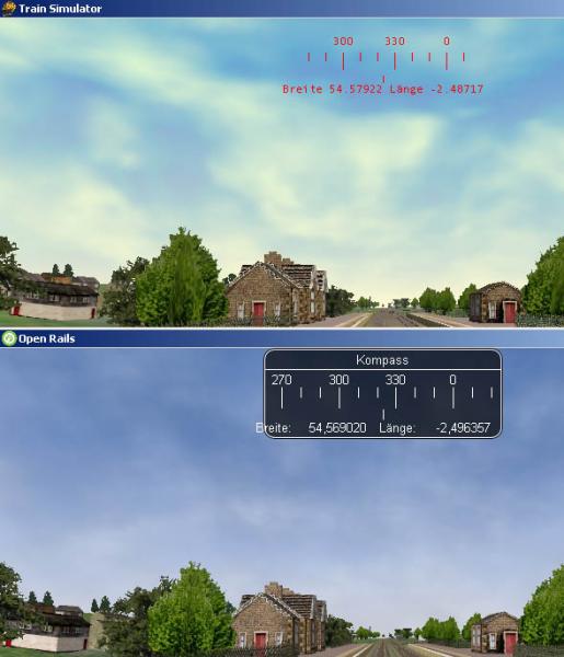
Anybody who knows why?

Best wishes,
Jonas

#2 User is offline   markus_GE 

  • Executive Vice President
  • PipPipPipPipPipPipPipPipPip
  • Group: ET Admin
  • Posts: 4,862
  • Joined: 07-February 13
  • Gender:Male
  • Location:Leoben, Styria, Austria, Europe
  • Simulator:ORTS / MSTS
  • Country:

Posted 16 June 2014 - 01:17 PM

Not related to your problem, but :pleasantry: for showing that compass shot... something to fix in the translation there *taking notes* ;)

Cheers, Markus

#3 User is online   James Ross 

  • Open Rails Developer
  • Group: Status: Elite Member
  • Posts: 5,491
  • Joined: 30-June 10
  • Gender:Not Telling
  • Simulator:Open Rails
  • Country:

Posted 16 June 2014 - 01:20 PM

The OR code that converts to lat/long has been known to be inaccurate for years. I wrote better code in one of my personal projects (which is public and licensed compatibly) but nobody (including me) has bothered to move it/use it, because it's an absolutely pain to test.

#4 User is offline   eric from trainsim 

  • Waste Disposal Engineer
  • Group: Private - Open Rails Developer
  • Posts: 1,578
  • Joined: 30-October 10
  • Gender:Male
  • Simulator:ORTS
  • Country:

Posted 16 June 2014 - 01:42 PM

Playing Devil's Advocate for a second, is there a need to show the lat/long at all?

Wouldn't world coordinates be more practical, especially as a route tester?...

#5 User is online   James Ross 

  • Open Rails Developer
  • Group: Status: Elite Member
  • Posts: 5,491
  • Joined: 30-June 10
  • Gender:Not Telling
  • Simulator:Open Rails
  • Country:

Posted 16 June 2014 - 11:34 PM

 eolesen, on 16 June 2014 - 01:42 PM, said:

Playing Devil's Advocate for a second, is there a need to show the lat/long at all?

Wouldn't world coordinates be more practical, especially as a route tester?...


The internal coordinate system data is shown on the Camera line of HUD/DEBUG; the GUI should show something appropriate for the simulation, for which lat/long is fine.

#6 User is offline   jonas 

  • Engineer
  • Group: Status: Contributing Member
  • Posts: 548
  • Joined: 04-April 14
  • Gender:Male
  • Simulator:MSTS & OR
  • Country:

Posted 17 June 2014 - 08:54 AM

 James Ross, on 16 June 2014 - 11:34 PM, said:

The internal coordinate system data is shown on the Camera line of HUD/DEBUG; the GUI should show something appropriate for the simulation, for which lat/long is fine.


In fact it is not really bothering to me ( Maybe, when OpenRails will have an own RouteEditor ).
It came to my attention when I fly with cam 8 through the routes world, find a shape, write down the lat/long values and then try to jump to it within the Route Editor of MSTS. I wondered that I was that far away from the shape.
In futur I will use the internal coordinate values from the HUD/DEBUG. Thank you for that hint.

Best wishes,
Jonas

#7 User is offline   dmrick44 

  • Hostler
  • Group: Status: Active Member
  • Posts: 51
  • Joined: 13-July 13
  • Gender:Male
  • Simulator:MSTS & OR
  • Country:

Posted 11 November 2016 - 04:35 PM

Just wanted to add my two cents... Since there's been a "why do we need coordinates" comment, I'll try and explain why they are important. Every time Mike and I work on the Siskiyou Route we end up using coordinates and not the tile's information. If you are like many of us who create routes, you'll find yourself using Google Maps or Google Earth to determine where things are in the real world... and then transfer those coordinates from Google into the Route Editor. Google Earth works great when it comes to transferring sets of data (locations) from Google Earth into a *.mkr file for the Route Editor. Mike and I created a utility for doing just that. Since I suspect that there are some of you who would like a utility that does that, I'll put the utility on our website. Give me a day or two to get it there... I want to make sure that it's "nice" to use. I'll probably have to type up a "How to use it" file to go with it. You'll find it listed on our TOOLS-N-TIPS page. There are also some other great tools on that page. Last but surely not least, the coordinates shown inside the OpenRails window are quite important. When we run an Activity, we use the Compass to grab locations where we observe things that need to be fixed. If the coordinates displayed in the Compass aren't accurate then we can't quickly locate what needs to be fixed inside the Route Editor. By the way, the site is Siskurail.com. Let me know if you run into any problems.

#8 User is offline   SP 0-6-0 

  • Foreman Of Engines
  • Group: Status: Contributing Member
  • Posts: 985
  • Joined: 12-November 05
  • Gender:Not Telling
  • Location:Another planet.
  • Simulator:MSTS/ORTS
  • Country:

Posted 11 November 2016 - 07:44 PM

James, I hope someday your fix can be incorporated.

Robert

#9 User is offline   Lindsayts 

  • Superintendant
  • Group: Status: Elite Member
  • Posts: 1,849
  • Joined: 25-November 11
  • Gender:Male
  • Country:

Posted 11 November 2016 - 10:38 PM

 James Ross, on 16 June 2014 - 01:20 PM, said:

The OR code that converts to lat/long has been known to be inaccurate for years. I wrote better code in one of my personal projects (which is public and licensed compatibly) but nobody (including me) has bothered to move it/use it, because it's an absolutely pain to test.


Sorry to bother you James, if the existing code is inaccuarte enough that its essentially unusable (as it appears to be) what would be wrong with at least trying the new code. A problem I am finding is the position as reported in OR differs not only from MSTS but from Goku's route editor as well. It would be LOVELY if all these agreed it would help much as it would enable Goku's editor to be much more used. I believe its CRITICAL for new content to be able to be done for OR, for instance in Australia all the old MSTS content developers have left MSTS for other trainsims that do have decent content developing tools.

An obvious way of testing is to have two independent systems side by side viewing the same route one on MSTS the other on OR, this is something I CAN do.

Lindsay

#10 User is offline   disc 

  • Foreman Of Engines
  • Group: Private - Open Rails Developer
  • Posts: 818
  • Joined: 07-October 12
  • Gender:Male
  • Simulator:OpenRails
  • Country:

Posted 12 November 2016 - 07:21 AM

 James Ross, on 16 June 2014 - 01:20 PM, said:

I wrote better code in one of my personal projects (which is public and licensed compatibly) but nobody (including me) has bothered to move it/use it, because it's an absolutely pain to test.


Then why don't you commit it, if it's better?

  • 2 Pages +
  • 1
  • 2
  • You cannot start a new topic
  • You cannot reply to this topic

1 User(s) are reading this topic
0 members, 1 guests, 0 anonymous users