 Log In
 Register Now!
 Help
Help

Interesting reads! Chicago has so much to look at and study in the way of bridges, architecture and the Elevated, not to mention the railroad action. That swing bridge you have to model is pretty cool. Do you have anything on it in the way of drawings, data, date of build?
Then and now
Rate Topic:

#11

- Member since Nov. 2003
-

- Group: Status: First Class
- Posts: 9,868
- Joined: 22-November 03
- Gender:Not Telling
- Location:Somewhere on the Beautiful Oregon Coast
- Simulator:Open Rails Only
-
Country:

Posted 23 December 2021 - 10:27 PM
#12
- Owner Emeritus and Admin
-

- Group: ET Admin Group
- Posts: 15,661
- Joined: 11-January 04
- Gender:Male
- Location:United States
- Simulator:Open Rails
-
Country:
Posted 24 December 2021 - 11:29 AM
 timmuir, on 23 December 2021 - 10:27 PM, said:
Interesting reads! Chicago has so much to look at and study in the way of bridges, architecture and the Elevated, not to mention the railroad action. That swing bridge you have to model is pretty cool. Do you have anything on it in the way of drawings, data, date of build?
No. But the MILW built two bobtailed swing bridges and I've already built the other one. Perhaps it's similar enough that i can use parts of it here.
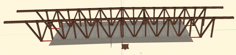
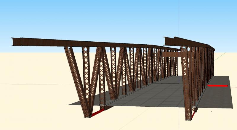
I need 4 railroad bridges, 33 street bridges. I've built 1 railroad bridge and have started on 1 street bridge. A lot of modeling... fortunately most of the street bridges use the same basic design so perhaps there will be something I can leverage across multiple models.
This 1939 photos shows a number of bridges on the north side of the Loop (north is to the right).
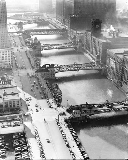
Second from the top is the one I've started to build (N. Wells St). It's different because they put the CTA Commuter rails up on top. What I've done so far:
I think the most interesting one is one of the older rail bridges:
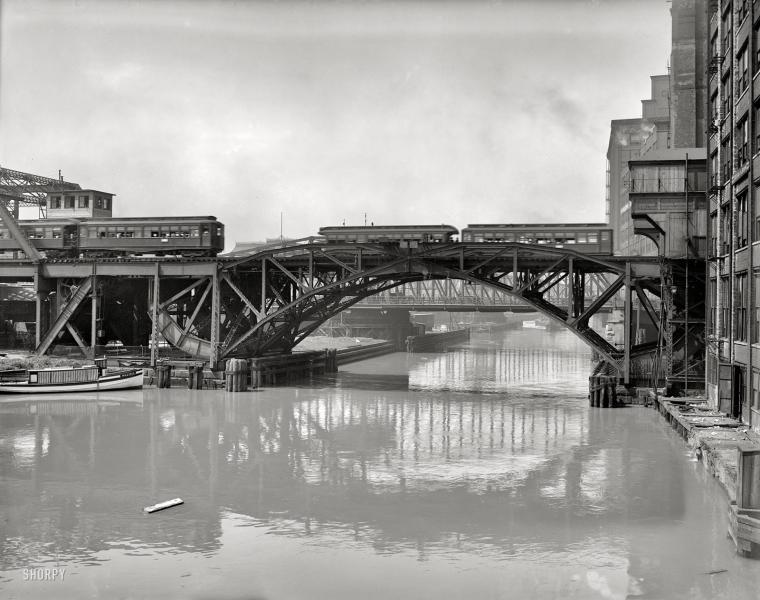
This is draw bridge for the east:west line that once carried the Chicago, Aurora & Elgin between far western suburbs and downtown. To the left the rails are above the glass topped trainshed of Union Station; to the right is a stub ended terminal squeezed between a couple of buildings. I think it looks really cool.
#13
- Member since Nov. 2003
-
- Group: Status: First Class
- Posts: 9,868
- Joined: 22-November 03
- Gender:Not Telling
- Location:Somewhere on the Beautiful Oregon Coast
- Simulator:Open Rails Only
-
Country:
Posted 29 October 2022 - 09:38 AM
A generally interesting read, although a bit before your route's era, this 1914 100 page booklet has some very cool graphics, maps, charts and photos dealing with railroad transit and transportation within Chicago. From the City Club of Chicago.
.Through Routes for Chicago's Steam Railroads
.Through Routes for Chicago's Steam Railroads
#14
- Owner Emeritus and Admin
-
- Group: ET Admin Group
- Posts: 15,661
- Joined: 11-January 04
- Gender:Male
- Location:United States
- Simulator:Open Rails
-
Country:
Posted 29 October 2022 - 10:18 AM
Cool. Thanks Tim!
#15
- Waste Disposal Engineer
-

- Group: Private - Open Rails Developer
- Posts: 1,795
- Joined: 30-October 10
- Gender:Male
- Simulator:ORTS
-
Country:
Posted 29 October 2022 - 11:40 AM
Catching up on this thread... I'd partly modeled the CNW track underneath the Merch Mart, but only as a stub to eventually do the line to Navy Pier. That diagram really helps.
#16
- Member since Nov. 2003
-
- Group: Status: First Class
- Posts: 9,868
- Joined: 22-November 03
- Gender:Not Telling
- Location:Somewhere on the Beautiful Oregon Coast
- Simulator:Open Rails Only
-
Country:
Posted 01 November 2022 - 03:18 PM
Here is another book you might find useful, if not interesting. First half of the book is text. The second half is a collection of maps and charts of the various railroads' terminals, some very detailed track charts. There's a map of just railroad buildings in the business district of Chicago, showing their respective footprints. Other maps detail proposed and under construction projects that impact the railroads, such as the river straightening project. Nicely detailed maps and track charts of freight terminals and yards, etc. This was printed in 1921, by the way.
It's in my favorites.
It's in my favorites.
#17
- Owner Emeritus and Admin
-
- Group: ET Admin Group
- Posts: 15,661
- Joined: 11-January 04
- Gender:Male
- Location:United States
- Simulator:Open Rails
-
Country:
Posted 01 November 2022 - 06:43 PM
Interesting, yes. Useful? One or two plates. Several of the plates are oversized foldout pages... that are not folded out. Many are obsolete because of the straightening of the Chicago River changed everything. It certainly does convey the magnitude of the rail operations in downtown Chicago. It is a keeper. Thanks!
#18
- Member, Board of Directors
-
- Group: ET Admin Group
- Posts: 5,554
- Joined: 06-October 09
- Gender:Male
- Location:Colorado and California
- Simulator:MSTS OR
-
Country:
Posted 02 November 2022 - 07:43 AM
wonderful finds Tim and very intersting for one who has studied architecture and development of Chicago both from my own famlily history and when i made a scale model of all of the structures in the Loop when i was in college in the 1970s using data from the Fire Department of Chicago.
Chris
Chris