Log In
 Register Now!
 Help
Help

I attempt to build realistic switching routes for Trainz and therefore tend to research random switching lines, such as the Brooklyn East District Terminal (http://members.trainweb.com/bedt/). Found Goose Island because I have a lot of Chicagoan friends at school and figured after railfanning a bit there this summer that there had to be some good switching lines. As it turned out Goose Island is one of only very few, but at the same time it's a pretty good one.
I'm still trying to build the modern-day variant in Trainz, as I'm hopeless with the MSTS route editor.
A couple of screenshots
Rate Topic:

#11

- Hostler
-

- Group: Posts: Active Member
- Posts: 58
- Joined: 29-June 08
- Gender:Male
- Simulator:MSTS
-
Country:

Posted 25 November 2012 - 10:39 AM
#12
- Owner Emeritus and Admin
-

- Group: ET Admin Group
- Posts: 15,661
- Joined: 11-January 04
- Gender:Male
- Location:United States
- Simulator:Open Rails
-
Country:
Posted 05 December 2012 - 12:06 AM
There are some tall buildings in Chicago (most models are in 1st phase construction -- get the shape done):
Far left is the Daily News building, built in 1929. I'm led to understand it was one of the early examples of using "air" rights: paid the railroad for the right to build "in the air" above their property. The railroad in question is Chicago's Union Station "railroad" and whats under the Daily News is the start of the throat that leads into the platform area on the north side of the station. That's where the PRR's Panhandle route and all of the MILW Rd brought their passenger trains.
The large red-brown buildings to the right of the Daily News are owned by Butler Brothers. I looked them up... they supplied all of the inventory to the Ben Franklin 5 & 10 franchises. They also owned the one building in this scene that's had the windows put in :oldstry: .
Behind them in the center of the picture is North American Cold Storage. Dunno if they stored met,veggies, both... corpses.... Whatever it was it stayed cold.
And over on the right is the Merchandise Mart.
All of these tall buildings are still standing in Chicago and can be viewed in Google Maps. A search on 600 West Kinzie will put you quite near the N.A. Cold Storage bldg.
For gauging size, there is a short train located on the tracks in front of Butler Brothers.
I'm pretty sure this shot will represent the furthest south I'm going to go with this route. I want to include enough track here to allow for AI trains to come out of the Union Station but I don't want to try and recreate the station itself as none of the passenger train traffic moved on the MILW Rd. path I am trying to recreate with this project.
Another view, this time from the Daily News building:
#13
- Foreman Of Engines
-

- Group: Status: First Class
- Posts: 945
- Joined: 18-June 11
- Gender:Male
-
Country:
Posted 05 December 2012 - 05:16 AM
Beautiful work Dave! :bravo:
I walk past this area every day on my way to and from work. I walk thru the old Daily News Building to get to the train station. As someone familiar with the area I've go to tell you that even without any textures applied to the buildings you have captured the area really well.
Best Regards,
Paul
I walk past this area every day on my way to and from work. I walk thru the old Daily News Building to get to the train station. As someone familiar with the area I've go to tell you that even without any textures applied to the buildings you have captured the area really well.
Best Regards,
Paul
#14
- Executive Vice President
-

- Group: Posts: Elite Member
- Posts: 3,354
- Joined: 02-August 07
- Gender:Male
-
Country:

Posted 05 December 2012 - 02:38 PM
Coming along great Dave! :bravo: I've been getting inspired from you in using the Geo Locations for my buildings as well. But curious why the resolution is so bad on mine? Some of the buildings I've downloaded have great resolution of the roofs. Which technically speaking still isn't that great I know. Is it to do with the selection size? As I've been trying to get pretty tight on things, but thinking now it maybe better to grab a large swath. But really like how you have it on your route.
#15
- Owner Emeritus and Admin
-
- Group: ET Admin Group
- Posts: 15,661
- Joined: 11-January 04
- Gender:Male
- Location:United States
- Simulator:Open Rails
-
Country:
Posted 05 December 2012 - 03:22 PM
 Noisemaker, on 05 December 2012 - 02:38 PM, said:
Coming along great Dave! :bravo: I've been getting inspired from you in using the Geo Locations for my buildings as well. But curious why the resolution is so bad on mine? Some of the buildings I've downloaded have great resolution of the roofs. Which technically speaking still isn't that great I know. Is it to do with the selection size? As I've been trying to get pretty tight on things, but thinking now it maybe better to grab a large swath. But really like how you have it on your route.
First, I'm not using any images from google streetview / earth / warehouse for my textures. Second, I do make an effort to keep the art pixel to model area ratio fairly similar in whatever mix of textures I use. If the ratio in texture A is wildly different than the ratio in texture B, you'll notice. Last, by using tiling textures as much as possible I'm able to get a low art pixel to model area ratio. I really don't want to be using textures that have worse resolution than what we all have been used to seeing on 40 foot boxcars: 512x512 pixels of artwork to cover about 40x40 feet... or roughly speaking a out 1 pixel of art per square inch of model. When you change that ratio so 1 pixel of art covers more area things start to look blurry... change it more and it looks flat out pixelated.
So what are the ratios you are typically using?
#16
- Executive Vice President
-
- Group: Posts: Elite Member
- Posts: 3,354
- Joined: 02-August 07
- Gender:Male
-
Country:
Posted 05 December 2012 - 07:53 PM
Surprisingly SU makes the image fairly small when I go to edit it. Even a big large factory roof appears less than 512x512 when I open it in paint. Yet some of the warehouse models have bases on them that are as clear and detailed almost like what you're using. Could they be using some other form of image as well then? I always wondered why Geo Location has the 'Set Manually' option - but maybe that's why? It's a shame then, as the views on Earth can be really great at times. But Geo Location seems to just butcher them in Sketch Up for some reason.
#17
- Owner Emeritus and Admin
-
- Group: ET Admin Group
- Posts: 15,661
- Joined: 11-January 04
- Gender:Male
- Location:United States
- Simulator:Open Rails
-
Country:
Posted 07 December 2012 - 11:33 PM
Gman347, on 05 December 2012 - 05:16 AM, said:
I walk past this area every day on my way to and from work. I walk thru the old Daily News Building to get to the train station. As someone familiar with the area I've go to tell you that even without any textures applied to the buildings you have captured the area really well.
Thanks Paul! Here's another image for you, something I just added that's directly across the river from the Daily News:
#18
- Foreman Of Engines
-
- Group: Status: First Class
- Posts: 945
- Joined: 18-June 11
- Gender:Male
-
Country:
Posted 08 December 2012 - 05:43 AM
That's the Civic Tower. The Lyric Opera of Chicago performs at the Opera House in that building. :shok: The office of one of my client's is also in that building.
Thanks again for sharing the shots. :sweatingbullets: It's a lot of fun watching the route develop.
Cheers,
Paul
Thanks again for sharing the shots. :sweatingbullets: It's a lot of fun watching the route develop.
Cheers,
Paul
#19
- Owner Emeritus and Admin
-
- Group: ET Admin Group
- Posts: 15,661
- Joined: 11-January 04
- Gender:Male
- Location:United States
- Simulator:Open Rails
-
Country:
Posted 09 December 2012 - 01:24 PM
One of the things I'm experimenting with is the use of large "sheets of glass", set to hishine, located behind 3D window frames. An example:
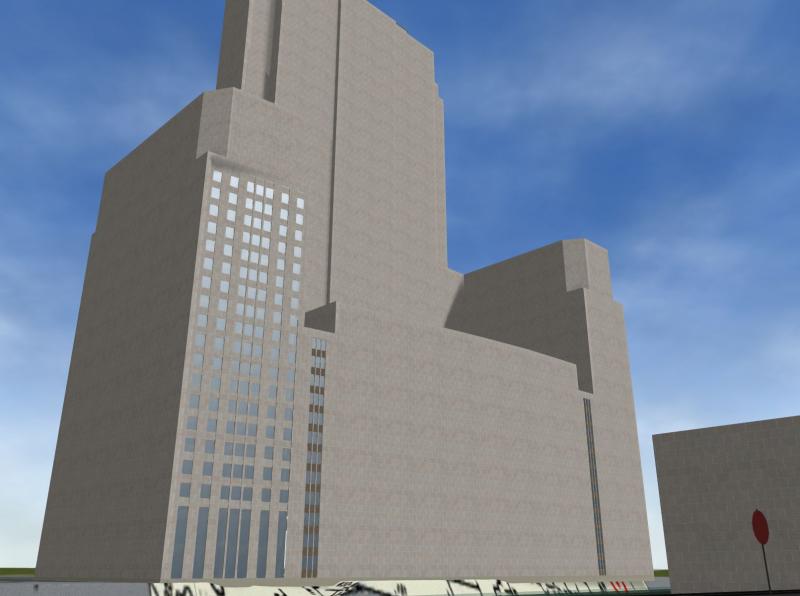
Eventually most of this building will look like the windowed section on the lift. Get down to train level (like this screenshot and the upper windows should be hishine in the sunlight... move the camera up to be able look down on the trains and the window reflection should shrink and move upwards with the camera.
I would think 1 bit alpha masks might do as well for the window cutouts (and save on the poly count too) but I've not yet tried that.
p.s. This particular building is over 500 feet tall and is just across the river about 125-150 feet off the tracks. Hard to miss.
#20
- Owner Emeritus and Admin
-
- Group: ET Admin Group
- Posts: 15,661
- Joined: 11-January 04
- Gender:Male
- Location:United States
- Simulator:Open Rails
-
Country:
Posted 07 March 2014 - 09:01 PM
Thank you Claus... you have such a good eye for composition! I'll bet you are very good w/ a real camera too.
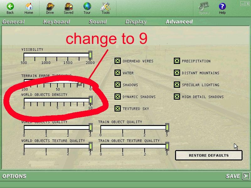
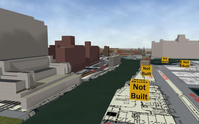
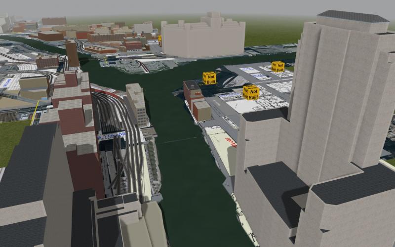
If you set the Display Level down 1 -- from 10 to 9 -- all of the push pins and Not Built boxes will be suppressed.
GI_W_Cooper_and_Nephews_Dtls.s. has too many polys for MSTS but will display in Open Rails (it's a bunch of pipes for transferring liquids). Not sure why GI_Halsted_at_Ancona.s does not display but it's most likely due to that missing .ace file you mentioned.
WRT the mini-route... the concern is the tsection.dat file I'm using has entries not found in the released version and given that I don't spend much effort keeping the rest of the file in sync with the published one. That should not be a problem for most people but I expect it could be a problem for someone and rather than take the blame for causing someone a real headache I'm recommending the mini-route method as the safest way to install.
I'm hoping to publish the next "alpha" in the next few days.
#21
- Foreman Of Engines
-
- Group: Status: First Class
- Posts: 921
- Joined: 04-June 11
- Gender:Male
- Simulator:No longer around
-
Country:

Posted 08 March 2014 - 03:13 AM
Thanks Dave :).
I checked the GI_W_Cooper_and_Nephews_Dtls.s out, and you're right, it's a bunch of pipes that looks amazing BTW :good2:. I got the GI_Halsted_at_Ancona.s up and running, I made a copy of the SLW_SP_Berm_Side.ace and renamed it to SLW_SP_Berms.ace, and it looks right/correct to me. It's a part of the structures for the elevated tracks.
I have already spent several hours on the Goose Island, and I'm still amazed by the amount of structures, the sheer size of some of the buildings and the complexity of the track work, this is going to be the urban and industrial route of the century, amazing work Dave.
Some additional scenes, and I've got plenty of those :lol2: :D .
http://imageshack.com/a/img34/9485/t805.jpg
At 400 W Washington looking east.
http://imageshack.com/a/img138/2572/g3oh.jpg
At 400 W Washington looking north.
http://imageshack.com/a/img853/2738/mpig.jpg
http://imageshack.com/a/img23/5198/iczm.jpg
Looking south along the Cherry St Bridge.
http://imageshack.com/a/img138/4124/kq9r.jpg
The approach to the Cherry St Bridge with Peoples Gas storage tanks in background.
http://imageshack.com/a/img842/9277/7siw.jpg
About 1000 W North Ave, looking west.
http://imageshack.com/a/img197/9727/rkph.jpg
Cherry St. Bridge.
http://imageshack.com/a/img27/4800/23na.jpg
Division St. Yard, looking south.
http://imageshack.com/a/img837/4311/jkqa.jpg
Firestone Tire warehouse at 1040 W. North Ave.
To be continued...
#22
- Member, Board of Directors
-
- Group: ET Admin Group
- Posts: 5,554
- Joined: 06-October 09
- Gender:Male
- Location:Colorado and California
- Simulator:MSTS OR
-
Country:
Posted 08 March 2014 - 06:28 AM
wondeful new work
#23
- Foreman Of Engines
-
- Group: Status: First Class
- Posts: 945
- Joined: 18-June 11
- Gender:Male
-
Country:
Posted 08 March 2014 - 06:54 AM
Claus,
I agree with Dave, you are a genious with a camera. Beautiful Shots.:)
Dave, I downloaded this route but have not had a chance to install it. From looking at Claus' shots I can tell it is going to be truly awesome. Living in the area and having some familiarity with it is going to make it even more fun to experience.
The structures are all gorgeous and very different from what we normally see in TS. No trees or mountains but a wonderful experience in its own right.
Your choice of textures for the various storage tanks is also really effective. They look great.
So that is the Kennedy Expressway in the foreground of the above shot. That certainly doesn't fit the period you are modeling. What are your plans for that? Or is that beyond the area you intend to depict in detail?
Really nice work. :D We are very fortunate to have you sharing this effort with us. :lol2: :good2:
Best,
Paul :D
I agree with Dave, you are a genious with a camera. Beautiful Shots.:)
Dave, I downloaded this route but have not had a chance to install it. From looking at Claus' shots I can tell it is going to be truly awesome. Living in the area and having some familiarity with it is going to make it even more fun to experience.
The structures are all gorgeous and very different from what we normally see in TS. No trees or mountains but a wonderful experience in its own right.
Your choice of textures for the various storage tanks is also really effective. They look great.
Quote
http://imageshack.com/a/img827/1533/zj76.jpg
So that is the Kennedy Expressway in the foreground of the above shot. That certainly doesn't fit the period you are modeling. What are your plans for that? Or is that beyond the area you intend to depict in detail?
Really nice work. :D We are very fortunate to have you sharing this effort with us. :lol2: :good2:
Best,
Paul :D
#24
- Owner Emeritus and Admin
-
- Group: ET Admin Group
- Posts: 15,661
- Joined: 11-January 04
- Gender:Male
- Location:United States
- Simulator:Open Rails
-
Country:
Posted 08 March 2014 - 09:54 AM
Gman347, on 08 March 2014 - 06:54 AM, said:
Claus,
I agree with Dave, you are a genious with a camera. Beautiful Shots.:)
Dave, I downloaded this route but have not had a chance to install it. From looking at Claus' shots I can tell it is going to be truly awesome. Living in the area and having some familiarity with it is going to make it even more fun to experience.
The structures are all gorgeous and very different from what we normally see in TS. No trees or mountains but a wonderful experience in its own right.
Your choice of textures for the various storage tanks is also really effective. They look great.
So that is the Kennedy Expressway in the foreground of the above shot. That certainly doesn't fit the period you are modeling. What are your plans for that? Or is that beyond the area you intend to depict in detail?
Really nice work. :D We are very fortunate to have you sharing this effort with us. :lol2: :good2:
Best,
Paul :D
I agree with Dave, you are a genious with a camera. Beautiful Shots.:)
Dave, I downloaded this route but have not had a chance to install it. From looking at Claus' shots I can tell it is going to be truly awesome. Living in the area and having some familiarity with it is going to make it even more fun to experience.
The structures are all gorgeous and very different from what we normally see in TS. No trees or mountains but a wonderful experience in its own right.
Your choice of textures for the various storage tanks is also really effective. They look great.
So that is the Kennedy Expressway in the foreground of the above shot. That certainly doesn't fit the period you are modeling. What are your plans for that? Or is that beyond the area you intend to depict in detail?
Really nice work. :D We are very fortunate to have you sharing this effort with us. :lol2: :good2:
Best,
Paul :D
Paul, thank you for your kind words... much appreciated.
I've taken screenshots from USAPhotoMap and turned them into tertex -- modern images -- and that's what you see in the foreground. Over time I've replaced individual images with the same location taken from the 1950-51 Sanborn maps -- and you can see that too in the screenshot you posted, in pale yellow (for this tile... other tiles use other colors). The combination of the two image types are guiding placement of objects as well as the location of the river and lakefront. Eventually I will replace both with tertex that looks like real terrain (I could really use some help on that 'cuz I hate doing tertex art).
Something else you will notice when you install the route is the track is all elevated ~1m above the ground. I've done that because I'm unsure how I want to handle the ROW... do I want to see a slope of any kind?... tracks almost buried? Both? I don't know yet and so I simply dropped he ground away and left the decision on what to do for later. And so in the meanwhile it looks a bit odd.
#25
- Owner Emeritus and Admin
-
- Group: ET Admin Group
- Posts: 15,661
- Joined: 11-January 04
- Gender:Male
- Location:United States
- Simulator:Open Rails
-
Country:
Posted 08 March 2014 - 04:02 PM
Claus, to suppress the display of the pins and not built boxes, go to MSTS options, then to Advanced, and change World Object Density to 9. In Open Rails you can set World Object Density to 9 using Options on the Video Tab.