Elvas Tower: A couple of screenshots - Elvas Tower

Jump to content

  • 3 Pages +
  • 1
  • 2
  • 3
  • You cannot start a new topic
  • You cannot reply to this topic

A couple of screenshots Rate Topic: -----

#1 User is offline   Genma Saotome 

  • Owner Emeritus and Admin
  • PipPipPipPipPipPipPipPipPipPipPipPipPip
  • Group: ET Admin Group
  • Posts: 15,655
  • Joined: 11-January 04
  • Gender:Male
  • Location:United States
  • Simulator:Open Rails
  • Country:

Posted 17 November 2012 - 10:26 PM

Still very early in construction but the general idea is beginning to shape up.

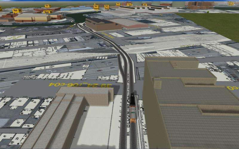
The "entrance" to the route is via the Bloomington Line, which connects the not-bo-be-modeled large Galewood Yard to the area around Goose Island. Knowing there is an interlocking where the Bloomington Line crosses the many-tracked C&NW main I could have activities start and end at the interlocking and thereby skip the 10 miles thru the neighborhoods to get to or from Galewood.

EB Waiting for clearance to cross the C&NW.
Attached Image: Clipboard01.jpg


Looking over to where the crossing will be (center of image):
Attached Image: Clipboard02.jpg


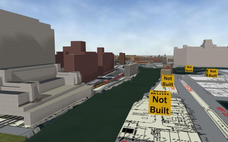
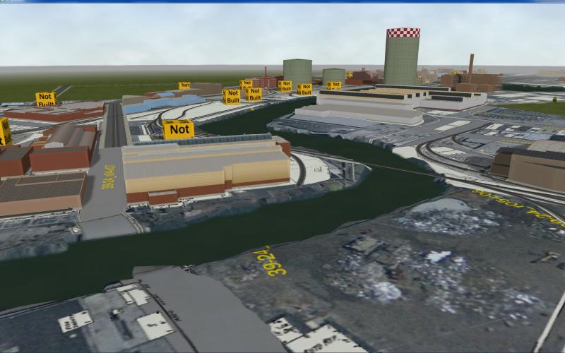
Location of the "Z-5 bridge" belongs (center right where the track is). This is a lateral swing bridge, rotating clockwise to clear for river traffic. In the distance you can see numerous "Not Built" cubes that I use to locate where structures will go. Better than MSTS Markers, when I build the actual model I just drop it into the /shapes folder and it will replace the cube.
Attached Image: Clipboard03.jpg


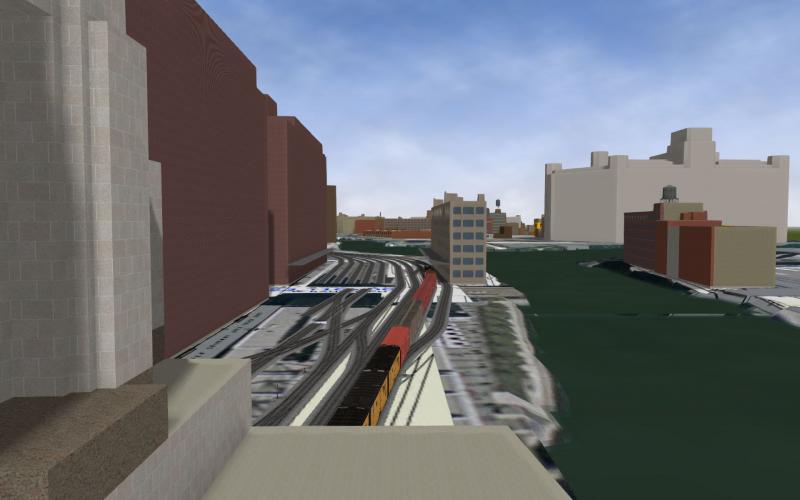
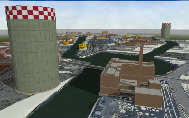
Looking south towards the Division St. Yard on Goose Island.
Attached Image: Clipboard04.jpg


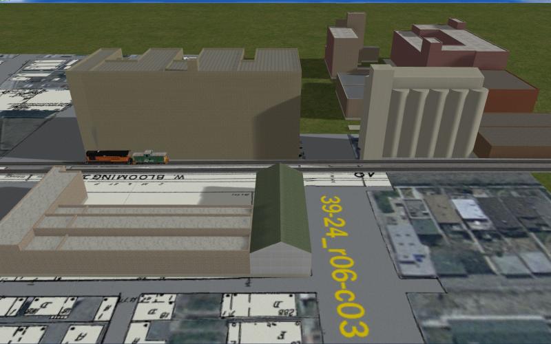
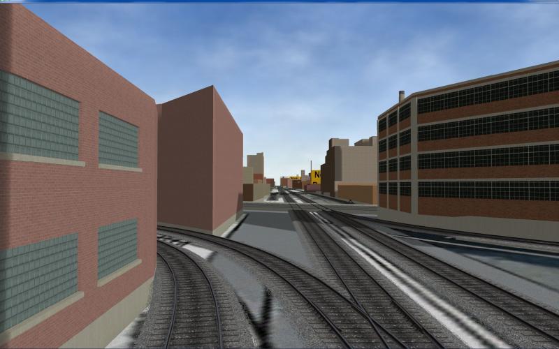
Looking south down Kingsbury from a few feet north of North Ave.
Attached Image: Clipboard05.jpg


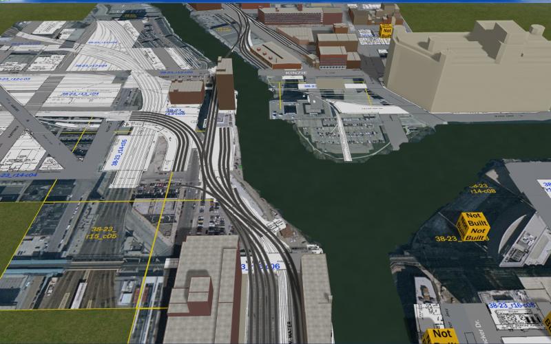
Jumping 2 miles south, starting to develop the interlocking on Canal street where the Kingsbury Line crosses the PRR Panhandle / Milwaukee Road Passenger Mains (from left) headed for Chicago's Union Station, a couple of streets to the south (below image). You can also see the C&NW tracks leading into their own station.
Attached Image: Clipboard06.jpg

#2 User is offline   cvo2010 

  • Foreman Of Engines
  • Group: Status: First Class
  • Posts: 921
  • Joined: 04-June 11
  • Gender:Male
  • Simulator:No longer around
  • Country:

Posted 18 November 2012 - 03:01 AM

Impressive work Dave, I have never seen anything like this.
It's going to be the industrial route of the century :D .

Regards Claus

#3 User is offline   captain_bazza 

  • Chairman, Board of Directors
  • PipPipPipPipPipPipPipPipPipPipPip
  • Group: ET Admin Group
  • Posts: 13,931
  • Joined: 21-February 06
  • Gender:Male
  • Location:Way, way, way, South
  • Simulator:MSTS & OR
  • Country:

Posted 18 November 2012 - 03:28 AM

Great work, Dave, it will be so easy to get lost amongst all that trackage.

Cheers Bazza

#4 User is offline   thegrindre 

  • Member, Board of Directors
  • Group: Posts: Elite Member
  • Posts: 8,349
  • Joined: 10-September 08
  • Gender:Male
  • Location:Now in central Arkansas
  • Simulator:MSTS & Trainz '04 & Open Rails
  • Country:

Posted 18 November 2012 - 04:23 AM

Just curious, Dave, how long you been building this 'route'?
Does it have a point A & point B or is this thing just a point A layout?

There is an awful lot of work to be done on this one, I can see. More then I'd want to tackle. :fiesta:

:D

#5 User is offline   JohnS 

  • Fireman
  • Group: Posts: Active Member
  • Posts: 231
  • Joined: 03-July 12
  • Gender:Male
  • Location:Portage, IN
  • Simulator:OR, MSTS, Railworks
  • Country:

Posted 18 November 2012 - 05:53 AM

WOW that's amazing Dave! You have a great talent.

#6 User is offline   Bernie 

  • Vice President
  • Group: Posts: Elite Member
  • Posts: 2,774
  • Joined: 06-March 10
  • Gender:Male
  • Location:Massachusetts
  • Simulator:MSTS
  • Country:

Posted 18 November 2012 - 06:16 AM

Wow, just stunning! :oldstry: How many more structures do you still have to work on? It looks like you are shaping up for a real industrial canyon!

#7 User is offline   Genma Saotome 

  • Owner Emeritus and Admin
  • PipPipPipPipPipPipPipPipPipPipPipPipPip
  • Group: ET Admin Group
  • Posts: 15,655
  • Joined: 11-January 04
  • Gender:Male
  • Location:United States
  • Simulator:Open Rails
  • Country:

Posted 18 November 2012 - 09:09 AM

Thanks for the comments guys.

@Clause: I'm simply setting down buildings & track per the maps I have and back around 1950. The basic shape and height of each building is correct to reality; when I can find an image of one I make adjustments to try and match the the color and where possible other exterior appearances.

@Barry: It's places like this that got me thinking of how can OR create sprite text whose display is controlled in activities... as in: Only show the sprites that are relevant. Something like that would go a long way to helping a player find his way around w/o getting lost.

@Rick: I started on May 4th, so 6 months and a few days.

@Bernie: I havn't counted the grand total but counting models plus not built cubes I come up with 170 .s files; Those that are real models will have 1 to > 20 structures, depending on the area covered. Doing the basic structure goes very quickly, adding the details like windows and doors just crawls. One problem I've noticed is all of the window textures I have on hand are correct for California and not for Chicago (real winters, older buildings). Maybe I'll have to go visit my Brother....

#8 User is offline   Mipman25 

  • Member, Board of Directors
  • Group: Posts: Elite Member
  • Posts: 5,244
  • Joined: 21-February 12
  • Gender:Male
  • Location:Reichensberg
  • Simulator:Open Rails
  • Country:

Posted 18 November 2012 - 04:19 PM

That's a really busy looking route there, Dave! Can't wait to see it when it's finished. Lots of places to drop things off at.

#9 User is offline   Robbie 

  • Hostler
  • Group: Posts: Active Member
  • Posts: 58
  • Joined: 29-June 08
  • Gender:Male
  • Simulator:MSTS
  • Country:

Posted 25 November 2012 - 01:52 AM

Well, this is impressive and somewhat coincidental that I just noticed this, considering I've been doing some research on the Goose Island line for a few weeks now.

I unfortunately mostly have only current pictures/data from the route, but I suppose I'll try to send you anything vintage that I have or find.

I did find a good close up view of the first Chicago River bridge, the swing bridge, on this page: Forgotten Chicago. I'm assuming that's the same as it was in the '50s so it may be of some help.

#10 User is offline   Genma Saotome 

  • Owner Emeritus and Admin
  • PipPipPipPipPipPipPipPipPipPipPipPipPip
  • Group: ET Admin Group
  • Posts: 15,655
  • Joined: 11-January 04
  • Gender:Male
  • Location:United States
  • Simulator:Open Rails
  • Country:

Posted 25 November 2012 - 09:52 AM

Hi Robbie, I found that Bloomingdale Line article a few weeks back -- elevated spurs, who'd have thought?

What got you interested in Goose Island?

#11 User is offline   Robbie 

  • Hostler
  • Group: Posts: Active Member
  • Posts: 58
  • Joined: 29-June 08
  • Gender:Male
  • Simulator:MSTS
  • Country:

Posted 25 November 2012 - 10:39 AM

I attempt to build realistic switching routes for Trainz and therefore tend to research random switching lines, such as the Brooklyn East District Terminal (http://members.trainweb.com/bedt/). Found Goose Island because I have a lot of Chicagoan friends at school and figured after railfanning a bit there this summer that there had to be some good switching lines. As it turned out Goose Island is one of only very few, but at the same time it's a pretty good one.

I'm still trying to build the modern-day variant in Trainz, as I'm hopeless with the MSTS route editor.

#12 User is offline   Genma Saotome 

  • Owner Emeritus and Admin
  • PipPipPipPipPipPipPipPipPipPipPipPipPip
  • Group: ET Admin Group
  • Posts: 15,655
  • Joined: 11-January 04
  • Gender:Male
  • Location:United States
  • Simulator:Open Rails
  • Country:

Posted 05 December 2012 - 12:06 AM

There are some tall buildings in Chicago (most models are in 1st phase construction -- get the shape done):

Attached Image: Clipboard0016.jpg

Far left is the Daily News building, built in 1929. I'm led to understand it was one of the early examples of using "air" rights: paid the railroad for the right to build "in the air" above their property. The railroad in question is Chicago's Union Station "railroad" and whats under the Daily News is the start of the throat that leads into the platform area on the north side of the station. That's where the PRR's Panhandle route and all of the MILW Rd brought their passenger trains.

The large red-brown buildings to the right of the Daily News are owned by Butler Brothers. I looked them up... they supplied all of the inventory to the Ben Franklin 5 & 10 franchises. They also owned the one building in this scene that's had the windows put in :oldstry: .

Behind them in the center of the picture is North American Cold Storage. Dunno if they stored met,veggies, both... corpses.... Whatever it was it stayed cold.

And over on the right is the Merchandise Mart.

All of these tall buildings are still standing in Chicago and can be viewed in Google Maps. A search on 600 West Kinzie will put you quite near the N.A. Cold Storage bldg.

For gauging size, there is a short train located on the tracks in front of Butler Brothers.

I'm pretty sure this shot will represent the furthest south I'm going to go with this route. I want to include enough track here to allow for AI trains to come out of the Union Station but I don't want to try and recreate the station itself as none of the passenger train traffic moved on the MILW Rd. path I am trying to recreate with this project.


Another view, this time from the Daily News building:

Attached Image: Clipboard0017.jpg

#13 User is offline   Gman347 

  • Foreman Of Engines
  • Group: Status: First Class
  • Posts: 945
  • Joined: 18-June 11
  • Gender:Male
  • Country:

Posted 05 December 2012 - 05:16 AM

Beautiful work Dave! :bravo:

I walk past this area every day on my way to and from work. I walk thru the old Daily News Building to get to the train station. As someone familiar with the area I've go to tell you that even without any textures applied to the buildings you have captured the area really well.

Best Regards,

Paul

#14 User is offline   Noisemaker 

  • Executive Vice President
  • Group: Posts: Elite Member
  • Posts: 3,354
  • Joined: 02-August 07
  • Gender:Male
  • Country:

Posted 05 December 2012 - 02:38 PM

Coming along great Dave! :bravo: I've been getting inspired from you in using the Geo Locations for my buildings as well. But curious why the resolution is so bad on mine? Some of the buildings I've downloaded have great resolution of the roofs. Which technically speaking still isn't that great I know. Is it to do with the selection size? As I've been trying to get pretty tight on things, but thinking now it maybe better to grab a large swath. But really like how you have it on your route.

#15 User is offline   Genma Saotome 

  • Owner Emeritus and Admin
  • PipPipPipPipPipPipPipPipPipPipPipPipPip
  • Group: ET Admin Group
  • Posts: 15,655
  • Joined: 11-January 04
  • Gender:Male
  • Location:United States
  • Simulator:Open Rails
  • Country:

Posted 05 December 2012 - 03:22 PM

View PostNoisemaker, on 05 December 2012 - 02:38 PM, said:

Coming along great Dave! :bravo: I've been getting inspired from you in using the Geo Locations for my buildings as well. But curious why the resolution is so bad on mine? Some of the buildings I've downloaded have great resolution of the roofs. Which technically speaking still isn't that great I know. Is it to do with the selection size? As I've been trying to get pretty tight on things, but thinking now it maybe better to grab a large swath. But really like how you have it on your route.


First, I'm not using any images from google streetview / earth / warehouse for my textures. Second, I do make an effort to keep the art pixel to model area ratio fairly similar in whatever mix of textures I use. If the ratio in texture A is wildly different than the ratio in texture B, you'll notice. Last, by using tiling textures as much as possible I'm able to get a low art pixel to model area ratio. I really don't want to be using textures that have worse resolution than what we all have been used to seeing on 40 foot boxcars: 512x512 pixels of artwork to cover about 40x40 feet... or roughly speaking a out 1 pixel of art per square inch of model. When you change that ratio so 1 pixel of art covers more area things start to look blurry... change it more and it looks flat out pixelated.

So what are the ratios you are typically using?

  • 3 Pages +
  • 1
  • 2
  • 3
  • You cannot start a new topic
  • You cannot reply to this topic

1 User(s) are reading this topic
0 members, 1 guests, 0 anonymous users