Elvas Tower: Laying Track - Elvas Tower

Jump to content

Page 1 of 1
  • You cannot start a new topic
  • You cannot reply to this topic

Laying Track Rate Topic: -----

#1 User is offline   Genma Saotome 

  • Owner Emeritus and Admin
  • PipPipPipPipPipPipPipPipPipPipPipPipPip
  • Group: ET Admin Group
  • Posts: 15,653
  • Joined: 11-January 04
  • Gender:Male
  • Location:United States
  • Simulator:Open Rails
  • Country:

Posted 28 September 2012 - 11:51 PM

I'm using Scale Rail -- wonder full stuff for lottsa curves, looks good too.

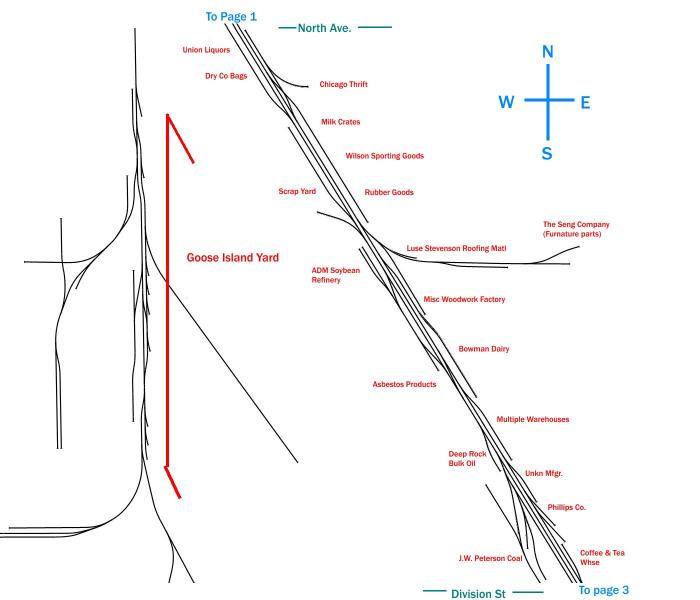
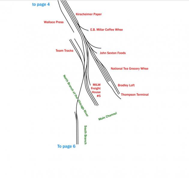
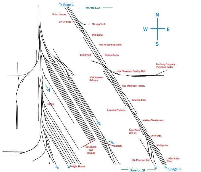
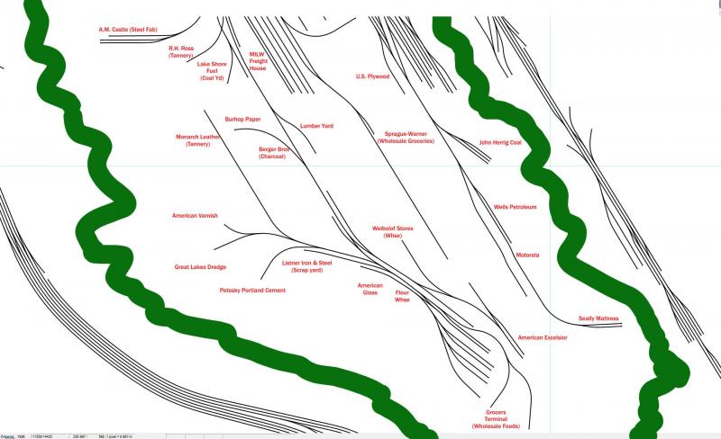
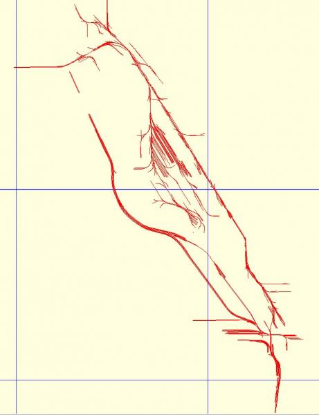
I'm taking my oft stated recommendations -- start laying track in the middle of the route so when you get tired of going in one direction you can turn around, find the other railhead, and push on from there. In this case it's "extra useful" because the route is, essentially, a big X and so in short order there will be 4 different railheads to work. The first section I'll work on is the Kingsbury Branch which runs along Kingsbury Ave. I'm starting at the north end of it, just north of the route's center.

It's almost 01:00 and so I'm posting just the first of three images... the other two will come sometime tomorrow.

Attached Image: Track01.jpg

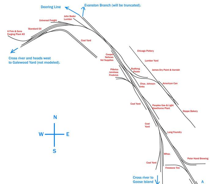
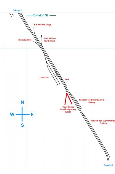
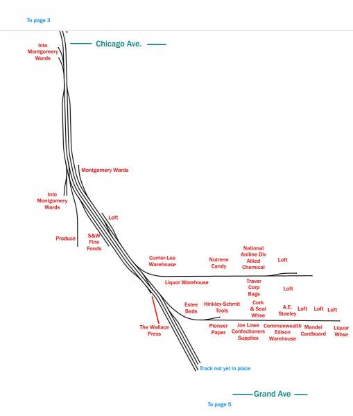
Most things there should be self evident... what's missing is the river, which is to the immediate left of the track and the scale of which I'm not really sure... but the top of the page is roughly where Cortland Ave is and the bottom is North Ave. On a due north south vertical axis that's about 750m and so from that you can see things are pretty congested -- curves into industry spots are as tight as 60m radius and the tangent run between successive turnouts is often in the 5-15m range, head to toe, so this is slow speed, small locomotive territory.

#2 User is offline   Genma Saotome 

  • Owner Emeritus and Admin
  • PipPipPipPipPipPipPipPipPipPipPipPipPip
  • Group: ET Admin Group
  • Posts: 15,653
  • Joined: 11-January 04
  • Gender:Male
  • Location:United States
  • Simulator:Open Rails
  • Country:

Posted 29 September 2012 - 10:31 AM

This image covers the distance between North Ave and Division and is about the same distance as the first map, roughly 750m north to south.

Attached Image: track02.jpg

Much of Kingsbury Ave was unpaved back in the day and I'll have to decide if I want to model it that way or pave it as it was later in 50's, as I do like street running.

Over on Goose Island proper, the MILW yard takes up the whole NE quarter and some of the SE quarter as well. The NW Corner has several large steel warehouses.

#3 User is offline   wacampbell 

  • Member since Nov. 2003
  • Group: Fan: Traction Nuts
  • Posts: 2,415
  • Joined: 22-November 03
  • Gender:Male
  • Location:British Columbia, Canada
  • Country:

Posted 29 September 2012 - 10:32 AM

View PostGenma Saotome, on 29 September 2012 - 10:31 AM, said:

This image covers the distance between North Ave and Division and is about the same distance as the first map, roughly 750m north to south.


Definitely the type of route I enjoy operating.

#4 User is offline   Genma Saotome 

  • Owner Emeritus and Admin
  • PipPipPipPipPipPipPipPipPipPipPipPipPip
  • Group: ET Admin Group
  • Posts: 15,653
  • Joined: 11-January 04
  • Gender:Male
  • Location:United States
  • Simulator:Open Rails
  • Country:

Posted 01 October 2012 - 10:25 AM

Page three starts around Division St, scale is about the same as the other maps. Tis sheet is the start of the many Montgomery Wards buildings -- Their National Catalog Sales shipping is here as are their centralized Corporate warehouses. On the other side of the tracks are facilities for one of the early Nation-wide Supermarket chains,

Attached Image: track03.jpg

Not shown above is the SE quarter of Goose Island -- the tracks have not been laid yet.

#5 User is offline   Genma Saotome 

  • Owner Emeritus and Admin
  • PipPipPipPipPipPipPipPipPipPipPipPipPip
  • Group: ET Admin Group
  • Posts: 15,653
  • Joined: 11-January 04
  • Gender:Male
  • Location:United States
  • Simulator:Open Rails
  • Country:

Posted 01 October 2012 - 10:28 AM

Page 4 continues with the Montgomery Wards sites and then transitions into the downtown warehouse district.

Attached Image: track04.jpg

Of particular note are the two long spurs that run east: not street running... alley running! Just 18 feet wide adjacent buildings that are 60, 70, 100 feet tall.

#6 User is offline   Noisemaker 

  • Executive Vice President
  • Group: Posts: Elite Member
  • Posts: 3,354
  • Joined: 02-August 07
  • Gender:Male
  • Country:

Posted 01 October 2012 - 01:01 PM

Just seems so immense diagram wise. But I guess these spurs hold one two cars at the most for the majority?

#7 User is offline   Genma Saotome 

  • Owner Emeritus and Admin
  • PipPipPipPipPipPipPipPipPipPipPipPipPip
  • Group: ET Admin Group
  • Posts: 15,653
  • Joined: 11-January 04
  • Gender:Male
  • Location:United States
  • Simulator:Open Rails
  • Country:

Posted 01 October 2012 - 01:15 PM

I'd say it is less than 3000m end-to-end... so what's that 1.25 miles? Here's the whole thing so far with the standard tile boundary included:

Attached Image: Track_Tiles.jpg

Am curious: Does it still seem so large to you now?


AFAIK there is no reason to go any further south than the bottom of lower right tile. Heading north, the Deerline line bends west to the edge of the upper left tile and then steers north for 1 tile. Neither the Evanston or Bloomington lines will go more than a half tile in distance... if that as I don't want to model them.

So I think when it adds up, the route will be just 3 tiles (6000m) long, which is what... 3.5 miles? Not that big really.

#8 User is offline   Noisemaker 

  • Executive Vice President
  • Group: Posts: Elite Member
  • Posts: 3,354
  • Joined: 02-August 07
  • Gender:Male
  • Country:

Posted 01 October 2012 - 03:53 PM

Wow! That's usually the average distance between GO stops up here. And doesn't take long at 50mph between them. Though I don't think one will ever get to that speed on this route of yours Dave. :oldstry: Just haven't seen a good industrial area like that in a long time. It's going to be something!

#9 User is offline   Genma Saotome 

  • Owner Emeritus and Admin
  • PipPipPipPipPipPipPipPipPipPipPipPipPip
  • Group: ET Admin Group
  • Posts: 15,653
  • Joined: 11-January 04
  • Gender:Male
  • Location:United States
  • Simulator:Open Rails
  • Country:

Posted 19 October 2012 - 08:56 PM

The ends the Kingsbury branch (400 West Kinzie Ave if you want to find it on a map). There is a lateral swing bridge that allows the MILW to cross the river and continue a few streets down to Union Station, perhaps points further south, but I'm going to keep that run at a minimum.

Attached Image: track05.jpg

This photo was taken several decades earlier but much of what is seen in it is present in the early 50's: The Railway Terminal Warehouse in the photo became The Wallace Press, the building in the center of the photo became E.B. Millar, center right is John Sexton Foods, the low building almost hidden behind the boxcars became the National Tea Grocery Warehouse and the building in the lower right is and remained the MILW Freight House #5.

#10 User is offline   Noisemaker 

  • Executive Vice President
  • Group: Posts: Elite Member
  • Posts: 3,354
  • Joined: 02-August 07
  • Gender:Male
  • Country:

Posted 20 October 2012 - 08:34 AM

You're going to have your work cut out for you when it comes to scenery is all I can say! ;) Thought I'd go at vamping a 'older area' on my GTA route. Buildings were done already in the 3D Warehouse, so I thought it'd be a cinch. But all the sections were individual, and the textures on them had trees and cars all over them! :friends: So it turned into a MAJOR undertaking for the rustic old, now modernized complex - but I did it!

http://i1214.photobucket.com/albums/cc485/TheNoisemaker/510FrontStw498and517WellingtonSt.jpg

When all was said and done though, it was pushing close to 2000 poly's! So seeing how the back part is never going to be seen, take it right out...

http://i1214.photobucket.com/albums/cc485/TheNoisemaker/510FrontStw498and517WellingtonStReduced.jpg

So it's something you may want to consider as well on your route? I know, I know - Open Rails doesn't give a fig about poly's, But - why push it? The more that could be saved is the more that could be had. And from the looks of it, you're going to be doing a LOT! But within such a tight confine, it maybe more noticeable on external camera views? Something to consider anyways. 100 polys here, 500 polys there, it adds up after awhile.

#11 User is offline   Genma Saotome 

  • Owner Emeritus and Admin
  • PipPipPipPipPipPipPipPipPipPipPipPipPip
  • Group: ET Admin Group
  • Posts: 15,653
  • Joined: 11-January 04
  • Gender:Male
  • Location:United States
  • Simulator:Open Rails
  • Country:

Posted 17 November 2012 - 09:59 PM

Beginning to get the Division Street Yard in located on Goose Island Proper. About 80% of the north end tracks are placed now:

Attached Image: track02 update.jpg

You can compare to diagram #2, well above, to see the changes.

It looks like there only three tracks for doing classification... seems that there will be more room to pull the block at the south end but I suppose if they were ok being on the Cherry St. bridge doing that work then either ned could be used.

Probably a dozen or so tracks available for queuing up outbound blocks and storing cars in protective service.

I can make out in my source material (very limited on the yard itself) where the scale track is and a different track for fueling steam locomotives. Then a handful for the freight house. A few tracks extend further south as leads to various industry tracks. Not a very big or complex yard.

#12 User is offline   Genma Saotome 

  • Owner Emeritus and Admin
  • PipPipPipPipPipPipPipPipPipPipPipPipPip
  • Group: ET Admin Group
  • Posts: 15,653
  • Joined: 11-January 04
  • Gender:Male
  • Location:United States
  • Simulator:Open Rails
  • Country:

Posted 15 February 2013 - 10:54 PM

Got the rest of the track down on the island:

Attached Image: Track06.jpg

That all attaches to the bottom of what is in the previous post. The green is kinda where the river is. Tracks are the far left are the C&NW Milwaukee Division Mainline -- full of commuter trains from the north suburbs.

And the whole route to date (the blue lines are tile boundaries so as you can see, it's all pretty compact):

Attached Image: Overview.jpg

#13 User is offline   Bernie 

  • Vice President
  • Group: Posts: Elite Member
  • Posts: 2,774
  • Joined: 06-March 10
  • Gender:Male
  • Location:Massachusetts
  • Simulator:MSTS
  • Country:

Posted 16 February 2013 - 11:14 AM

Compact, yes. Small? No! :pardon: You have a heck of a lot of track and custom buildings for this route, and a lot of invested time so far. It's really showing! :oldstry: So, with everything crammed onto those few tiles, how are the framerates?

#14 User is offline   Genma Saotome 

  • Owner Emeritus and Admin
  • PipPipPipPipPipPipPipPipPipPipPipPipPip
  • Group: ET Admin Group
  • Posts: 15,653
  • Joined: 11-January 04
  • Gender:Male
  • Location:United States
  • Simulator:Open Rails
  • Country:

Posted 16 February 2013 - 11:37 AM

View PostBernie, on 16 February 2013 - 11:14 AM, said:

So, with everything crammed onto those few tiles, how are the framerates?


Not as good as I thought I'd see. ScaleRail is very costly... each placed shape (tangent or curve) is 5 primitives and the turnouts are 23. Each primitive is a draw call (performance expensive) and while their textures can be shared within VRAM I'm led to understand that the work load for identical shapes is not "shared"... that each one gets all their required draw calls, moving all the necessary mesh no matter how many identical occurrences there are. With a very fast CPU and good video card that work can be done 60 or even 72 times per second (the rate at what most monitors actually can draw) but on my PC, which is a rather decent PC, it can only squeeze in 30 per sec... fps of 30.

The other factor is due to my use of Sketchup PLUS how I do models -- w/ 3d features. So they have a higher poly count (not too expensive in OR but every one does count) as well as more than necessary textures due to the SU Exporter Bug (see the Announcements forum for "I need some software help"). If the exporter bug can be fixed then it would be possible to consolidate some textures and possibly even shrink the size of the .s file, both of which would improve performance.

Over the long run, I expect the exporter will get fixed. I also expect OR to eventually allow for procedurally generated track (what RW does) which should allow for the creation of good looking track using a fewer textures as well as being more efficient in rendering than can be done today w/ all of those shapes. Eventually.

#15 User is offline   Bernie 

  • Vice President
  • Group: Posts: Elite Member
  • Posts: 2,774
  • Joined: 06-March 10
  • Gender:Male
  • Location:Massachusetts
  • Simulator:MSTS
  • Country:

Posted 16 February 2013 - 12:51 PM

Well, I suppose it helps that you are building a route heavy on switching; slow speeds can trick the eye into smoothing frame "jumps" out. In any rate (pun not intended... :oldstry: ), good luck! :pardon:

Page 1 of 1
  • You cannot start a new topic
  • You cannot reply to this topic

1 User(s) are reading this topic
0 members, 1 guests, 0 anonymous users